Arrifana (Kanguru / Kangaroo point) Surf Report
| Wave height * | 5.5ft / 1.7m |
|---|---|
| Swell period | 12s |
| Swell direction | |
| Wind | |
| Sea temp | 16°C / 60°F |

10 day Arrifana surf forecast
Mon
5/Jan
5.5ft
8
14
15
- High 3:18am
- Low 9:37am
- High 3:48pm
- Low 9:44pm
Tue
6/Jan
5ft
10
11
8
- High 4:03am
- Low 10:22am
- High 4:33pm
- Low 10:28pm
Wed
7/Jan
3ft
3
3
2
- High 4:48am
- Low 11:06am
- High 5:17pm
- Low 11:11pm
Thu
8/Jan
2.5ft
3
1
5
- High 5:32am
- Low 11:51am
- High 6:02pm
- Low 11:57pm
Fri
9/Jan
3.5ft
5
9
6
- High 6:19am
- Low 12:38pm
- High 6:50pm
Sat
10/Jan
4.5ft
5
6
6
- Low 12:47am
- High 7:09am
- Low 1:29pm
- High 7:44pm
Sun
11/Jan
3.5ft
2
5
5
- Low 1:47am
- High 8:07am
- Low 2:29pm
- High 8:47pm
Mon
12/Jan
5.5ft
9
15
13
- Low 3:00am
- High 9:15am
- Low 3:37pm
- High 9:57pm
Tue
13/Jan
5.5ft
21
15
13
- Low 4:19am
- High 10:28am
- Low 4:43pm
- High 11:02pm
Wed
14/Jan
9.5ft
26
24
22
- Low 5:25am
- High 11:32am
- Low 5:40pm
Mon 5th Jan
| 3:00 | 4.5ft | 6.8ft | 9s | 9mph (18mph) | |||
| 6:00 | 4.5ft | 7.5ft | 11s | 8mph (17mph) | |||
| 9:00 | 5.5ft | 8.7ft | 12s | 11mph (25mph) | |||
| 12:00 | 5.5ft | 9.1ft | 11s | 14mph (22mph) | |||
| 15:00 | 6ft | 9.4ft | 11s | 17mph (26mph) | |||
| 18:00 | 6ft | 10ft | 10s | 15mph (29mph) | |||
| 21:00 | 6ft | 10.1ft | 10s | 16mph (33mph) |
| Tide times |
|---|
| High 3:18am (3.54m) |
| Low 9:37am (0.48m) |
| High 3:48pm (3.20m) |
| Low 9:44pm (0.69m) |
| Daylight | |
|---|---|
| First light | 07:21 |
| Sunrise | 07:49 |
| Sunset | 17:31 |
| Dark | 18:00 |
Tue 6th Jan
| 3:00 | 4.5ft | 7.8ft | 9s | 10mph (27mph) | |||
| 6:00 | 5.5ft | 8.5ft | 10s | 10mph (28mph) | |||
| 9:00 | 5.5ft | 8.6ft | 10s | 9mph (26mph) | |||
| 12:00 | 5ft | 8.1ft | 10s | 11mph (19mph) | |||
| 15:00 | 5ft | 7.7ft | 10s | 13mph (19mph) | |||
| 18:00 | 5ft | 7.5ft | 10s | 8mph (21mph) | |||
| 21:00 | 4ft | 7.2ft | 10s | 7mph (21mph) |
| Tide times |
|---|
| High 4:03am (3.49m) |
| Low 10:22am (0.57m) |
| High 4:33pm (3.11m) |
| Low 10:28pm (0.78m) |
| Daylight | |
|---|---|
| First light | 07:21 |
| Sunrise | 07:49 |
| Sunset | 17:32 |
| Dark | 18:01 |
Wed 7th Jan
| 3:00 | 3.5ft | 6.3ft | 9s | 5mph (12mph) | |||
| 6:00 | 3ft | 5.5ft | 9s | 3mph (5mph) | |||
| 9:00 | 3ft | 4.9ft | 9s | 2mph (3mph) | |||
| 12:00 | 3ft | 5.1ft | 10s | 3mph (7mph) | |||
| 15:00 | 3.5ft | 5.8ft | 8s | 3mph (6mph) | |||
| 18:00 | 4ft | 6.3ft | 8s | 2mph (5mph) | |||
| 21:00 | 3.5ft | 6.4ft | 9s | 4mph (4mph) |
| Tide times |
|---|
| High 4:48am (3.37m) |
| Low 11:06am (0.71m) |
| High 5:17pm (2.98m) |
| Low 11:11pm (0.91m) |
| Daylight | |
|---|---|
| First light | 07:21 |
| Sunrise | 07:49 |
| Sunset | 17:33 |
| Dark | 18:02 |
Thu 8th Jan
| 3:00 | 3ft | 5.5ft | 9s | 4mph (4mph) | |||
| 6:00 | 3ft | 5ft | 9s | 3mph (2mph) | |||
| 9:00 | 3ft | 4.6ft | 10s | 2mph (2mph) | |||
| 12:00 | 2.5ft | 4.3ft | 11s | 1mph (2mph) | |||
| 15:00 | 3ft | 4.1ft | 11s | 5mph (4mph) | |||
| 18:00 | 3ft | 3.8ft | 11s | 5mph (8mph) | |||
| 21:00 | 3ft | 3.6ft | 11s | 4mph (7mph) |
| Tide times |
|---|
| High 5:32am (3.21m) |
| Low 11:51am (0.88m) |
| High 6:02pm (2.84m) |
| Low 11:57pm (1.07m) |
| Daylight | |
|---|---|
| First light | 07:21 |
| Sunrise | 07:49 |
| Sunset | 17:34 |
| Dark | 18:03 |
Fri 9th Jan
| 3:00 | 2.5ft | 3.4ft | 10s | 4mph (8mph) | |||
| 6:00 | 2.5ft | 3.4ft | 13s | 5mph (11mph) | |||
| 9:00 | 3ft | 3.6ft | 13s | 8mph (17mph) | |||
| 12:00 | 3.5ft | 4.6ft | 13s | 9mph (17mph) | |||
| 15:00 | 4.5ft | 6.2ft | 12s | 9mph (18mph) | |||
| 18:00 | 5ft | 7.7ft | 12s | 6mph (11mph) | |||
| 21:00 | 6ft | 8.1ft | 12s | 6mph (12mph) |
| Tide times |
|---|
| High 6:19am (3.01m) |
| Low 12:38pm (1.06m) |
| High 6:50pm (2.70m) |
| Daylight | |
|---|---|
| First light | 07:21 |
| Sunrise | 07:49 |
| Sunset | 17:35 |
| Dark | 18:04 |
Sat 10th Jan
| 3:00 | 5.5ft | 7.6ft | 12s | 6mph (9mph) | |||
| 6:00 | 5.5ft | 7.3ft | 12s | 5mph (6mph) | |||
| 9:00 | 4.5ft | 7.2ft | 12s | 4mph (6mph) | |||
| 12:00 | 4.5ft | 7.4ft | 12s | 6mph (11mph) | |||
| 15:00 | 4.5ft | 7.5ft | 13s | 7mph (9mph) | |||
| 18:00 | 4.5ft | 7.4ft | 12s | 6mph (9mph) | |||
| 21:00 | 4.5ft | 7.2ft | 12s | 5mph (6mph) |
| Tide times |
|---|
| Low 12:47am (1.23m) |
| High 7:09am (2.81m) |
| Low 1:29pm (1.22m) |
| High 7:44pm (2.58m) |
| Daylight | |
|---|---|
| First light | 07:20 |
| Sunrise | 07:49 |
| Sunset | 17:36 |
| Dark | 18:05 |
Sun 11th Jan
| 3:00 | 4.5ft | 6.8ft | 12s | 3mph (2mph) | |||
| 6:00 | 4ft | 6.6ft | 12s | 2mph (2mph) | |||
| 9:00 | 4ft | 6.3ft | 12s | 2mph (2mph) | |||
| 12:00 | 3.5ft | 5.9ft | 12s | 5mph (7mph) | |||
| 15:00 | 3.5ft | 5.5ft | 11s | 6mph (7mph) | |||
| 18:00 | 3ft | 5ft | 11s | 5mph (8mph) | |||
| 21:00 | 3ft | 4.5ft | 11s | 5mph (11mph) |
| Tide times |
|---|
| Low 1:47am (1.37m) |
| High 8:07am (2.63m) |
| Low 2:29pm (1.35m) |
| High 8:47pm (2.52m) |
| Daylight | |
|---|---|
| First light | 07:20 |
| Sunrise | 07:49 |
| Sunset | 17:37 |
| Dark | 18:06 |
Mon 12th Jan
| 3:00 | 2.5ft | 3.8ft | 10s | 9mph (21mph) | |||
| 6:00 | 3ft | 4.4ft | 10s | 9mph (21mph) | |||
| 9:00 | 4ft | 5.7ft | 11s | 10mph (21mph) | |||
| 12:00 | 5.5ft | 7.3ft | 11s | 15mph (25mph) | |||
| 15:00 | 5.5ft | 7.5ft | 10s | 18mph (30mph) | |||
| 18:00 | 5.5ft | 6.8ft | 10s | 13mph (26mph) | |||
| 21:00 | 5ft | 6.2ft | 10s | 14mph (26mph) |
| Tide times |
|---|
| Low 3:00am (1.45m) |
| High 9:15am (2.51m) |
| Low 3:37pm (1.41m) |
| High 9:57pm (2.52m) |
| Daylight | |
|---|---|
| First light | 07:20 |
| Sunrise | 07:49 |
| Sunset | 17:38 |
| Dark | 18:06 |
Tue 13th Jan
| 3:00 | 4.5ft | 5.6ft | 9s | 20mph (34mph) | |||
| 6:00 | 4.5ft | 6.2ft | 12s | 21mph (36mph) | |||
| 9:00 | 5ft | 7ft | 12s | 19mph (32mph) | |||
| 12:00 | 5.5ft | 7.4ft | 12s | 15mph (28mph) | |||
| 15:00 | 5.5ft | 7.3ft | 12s | 13mph (21mph) | |||
| 18:00 | 5ft | 7.1ft | 12s | 13mph (23mph) | |||
| 21:00 | 5ft | 7ft | 12s | 15mph (28mph) |
| Tide times |
|---|
| Low 4:19am (1.44m) |
| High 10:28am (2.48m) |
| Low 4:43pm (1.40m) |
| High 11:02pm (2.60m) |
| Daylight | |
|---|---|
| First light | 07:20 |
| Sunrise | 07:48 |
| Sunset | 17:39 |
| Dark | 18:07 |
Wed 14th Jan
| 3:00 | 6ft | 8.6ft | 13s | 29mph (49mph) | |||
| 6:00 | 7ft | 10.1ft | 13s | 26mph (45mph) | |||
| 9:00 | 8ft | 11.4ft | 13s | 27mph (44mph) | |||
| 12:00 | 9.5ft | 13.8ft | 13s | 24mph (41mph) | |||
| 15:00 | 12.5ft | 16.9ft | 13s | 24mph (37mph) | |||
| 18:00 | 12.5ft | 16.9ft | 17s | 22mph (32mph) | |||
| 21:00 | 12.5ft | 16.8ft | 17s | 17mph (28mph) |
| Tide times |
|---|
| Low 5:25am (1.36m) |
| High 11:32am (2.53m) |
| Low 5:40pm (1.33m) |
| Daylight | |
|---|---|
| First light | 07:20 |
| Sunrise | 07:48 |
| Sunset | 17:40 |
| Dark | 18:08 |
Top quality righthand pointbreak under the cliffs at the north end of the beach. Only starts working at size and the line up is dotted with boils and exposed rocks. Powerful, fast and hollow in places
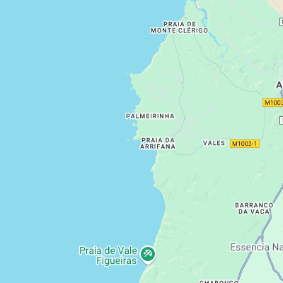
Surf spots nearby
- Lage do Pescador (1.9 mi)
- Figueiros (3.2 mi)
- Vale Figueira (3.2 mi)
- Monte Clerigo (3.6 mi)
- Amoreira (4.1 mi)
- Praia do Bordeira (6.7 mi)
- Carrapateira (6.8 mi)
- Praia do Amado (9 mi)
- Odeceixe (11 mi)
- Cordoama (13.6 mi)
Not Magic Seaweed (MSW)
Although we look a bit like Magic Seaweed we are not MagicSeaweed as they no longer exist...