Thunders Surf Report
| Wave height * | 3.5ft / 1m |
|---|---|
| Swell period | 10s |
| Swell direction | |
| Wind | |
| Sea temp | 29°C / 84°F |

10 day Thunders surf forecast
Tue
6/Jan
3ft
3
9
5
- High 9:32am
Wed
7/Jan
2.5ft
2
8
4
- Low 12:10am
- High 10:09am
Thu
8/Jan
1.5ft
1
4
4
- Low 12:41am
- High 10:42am
Fri
9/Jan
2ft
2
7
6
- Low 1:04am
- High 11:09am
Sat
10/Jan
3.5ft
5
9
8
- Low 12:56am
- High 11:28am
- Low 9:30pm
Sun
11/Jan
2ft
11
13
7
- High 11:28am
- Low 8:29pm
Mon
12/Jan
1.5ft
3
8
6
- High 10:30am
- Low 7:58pm
Tue
13/Jan
1.5ft
4
7
5
- High 6:05am
- Low 7:43pm
Wed
14/Jan
2ft
4
9
6
- High 5:52am
- Low 7:46pm
Tue 6th Jan
| 4:00 | 3.5ft | 4.3ft | 10s | 4mph (5mph) | |||
| 7:00 | 3ft | 4.1ft | 9s | 3mph (5mph) | |||
| 10:00 | 3ft | 4ft | 9s | 6mph (8mph) | |||
| 13:00 | 3ft | 3.9ft | 9s | 9mph (9mph) | |||
| 16:00 | 3ft | 3.7ft | 9s | 10mph (10mph) | |||
| 19:00 | 3ft | 3.6ft | 9s | 5mph (6mph) |
| Tide times |
|---|
| High 9:32am (4.17m) |
| Daylight | |
|---|---|
| First light | 05:53 |
| Sunrise | 06:15 |
| Sunset | 18:33 |
| Dark | 18:55 |
Wed 7th Jan
| 4:00 | 2.5ft | 3.4ft | 12s | 2mph (3mph) | |||
| 7:00 | 2.5ft | 3.3ft | 11s | 2mph (2mph) | |||
| 10:00 | 2.5ft | 3.2ft | 11s | 4mph (5mph) | |||
| 13:00 | 2.5ft | 3.1ft | 11s | 8mph (6mph) | |||
| 16:00 | 2.5ft | 3.1ft | 11s | 7mph (7mph) | |||
| 19:00 | 2.5ft | 3ft | 11s | 4mph (5mph) |
| Tide times |
|---|
| Low 12:10am (0.18m) |
| High 10:09am (4.00m) |
| Daylight | |
|---|---|
| First light | 05:53 |
| Sunrise | 06:16 |
| Sunset | 18:33 |
| Dark | 18:56 |
Thu 8th Jan
| 4:00 | 2.5ft | 3ft | 11s | 3mph (3mph) | |||
| 7:00 | 2.5ft | 3ft | 11s | 1mph (1mph) | |||
| 10:00 | 2.5ft | 3.1ft | 14s | 2mph (2mph) | |||
| 13:00 | 1.5ft | 3.2ft | 15s | 4mph (4mph) | |||
| 16:00 | 1.5ft | 3.4ft | 15s | 7mph (7mph) | |||
| 19:00 | 2ft | 3.5ft | 15s | 4mph (4mph) |
| Tide times |
|---|
| Low 12:41am (0.39m) |
| High 10:42am (3.74m) |
| Daylight | |
|---|---|
| First light | 05:54 |
| Sunrise | 06:16 |
| Sunset | 18:34 |
| Dark | 18:56 |
Fri 9th Jan
| 4:00 | 2ft | 3.8ft | 14s | 2mph (2mph) | |||
| 7:00 | 2ft | 3.7ft | 14s | 2mph (3mph) | |||
| 10:00 | 2ft | 3.7ft | 13s | 5mph (7mph) | |||
| 13:00 | 2ft | 3.7ft | 13s | 7mph (9mph) | |||
| 16:00 | 2ft | 3.6ft | 13s | 7mph (11mph) | |||
| 19:00 | 2ft | 3.6ft | 13s | 6mph (10mph) |
| Tide times |
|---|
| Low 1:04am (0.69m) |
| High 11:09am (3.41m) |
| Daylight | |
|---|---|
| First light | 05:54 |
| Sunrise | 06:17 |
| Sunset | 18:34 |
| Dark | 18:56 |
Sat 10th Jan
| 4:00 | 2ft | 3.7ft | 13s | 3mph (4mph) | |||
| 7:00 | 3.5ft | 3.8ft | 12s | 5mph (8mph) | |||
| 10:00 | 3ft | 4ft | 11s | 7mph (9mph) | |||
| 13:00 | 3.5ft | 4.5ft | 11s | 9mph (10mph) | |||
| 16:00 | 3.5ft | 4.8ft | 11s | 9mph (12mph) | |||
| 19:00 | 3ft | 4.6ft | 11s | 8mph (13mph) |
| Tide times |
|---|
| Low 12:56am (1.04m) |
| High 11:28am (3.03m) |
| Low 9:30pm (1.29m) |
| Daylight | |
|---|---|
| First light | 05:55 |
| Sunrise | 06:17 |
| Sunset | 18:34 |
| Dark | 18:57 |
Sun 11th Jan
| 4:00 | 3ft | 4.2ft | 10s | 9mph (17mph) | |||
| 7:00 | 2.5ft | 3.9ft | 11s | 11mph (20mph) | |||
| 10:00 | 2.5ft | 3.7ft | 11s | 12mph (21mph) | |||
| 13:00 | 2ft | 3.6ft | 11s | 13mph (22mph) | |||
| 16:00 | 2ft | 3.5ft | 11s | 10mph (20mph) | |||
| 19:00 | 1.5ft | 3.4ft | 11s | 7mph (14mph) |
| Tide times |
|---|
| High 11:28am (2.65m) |
| Low 8:29pm (1.33m) |
| Daylight | |
|---|---|
| First light | 05:55 |
| Sunrise | 06:18 |
| Sunset | 18:35 |
| Dark | 18:57 |
Mon 12th Jan
| 4:00 | 1.5ft | 3.3ft | 10s | 4mph (5mph) | |||
| 7:00 | 1.5ft | 3.3ft | 10s | 3mph (4mph) | |||
| 10:00 | 1.5ft | 3.3ft | 10s | 4mph (5mph) | |||
| 13:00 | 1.5ft | 3.2ft | 10s | 8mph (9mph) | |||
| 16:00 | 1.5ft | 3.2ft | 10s | 8mph (9mph) | |||
| 19:00 | 1.5ft | 3.2ft | 10s | 6mph (7mph) |
| Tide times |
|---|
| High 10:30am (2.34m) |
| Low 7:58pm (1.24m) |
| Daylight | |
|---|---|
| First light | 05:56 |
| Sunrise | 06:18 |
| Sunset | 18:35 |
| Dark | 18:57 |
Tue 13th Jan
| 4:00 | 2ft | 3.2ft | 10s | 3mph (4mph) | |||
| 7:00 | 2ft | 3.2ft | 10s | 4mph (4mph) | |||
| 10:00 | 1.5ft | 3.2ft | 9s | 4mph (6mph) | |||
| 13:00 | 1.5ft | 3.1ft | 9s | 7mph (7mph) | |||
| 16:00 | 1.5ft | 3.1ft | 9s | 9mph (9mph) | |||
| 19:00 | 1.5ft | 3.2ft | 9s | 5mph (5mph) |
| Tide times |
|---|
| High 6:05am (2.48m) |
| Low 7:43pm (1.07m) |
| Daylight | |
|---|---|
| First light | 05:56 |
| Sunrise | 06:18 |
| Sunset | 18:36 |
| Dark | 18:58 |
Wed 14th Jan
| 4:00 | 3ft | 4.2ft | 14s | 4mph (5mph) | |||
| 7:00 | 3ft | 4ft | 15s | 4mph (4mph) | |||
| 10:00 | 2.5ft | 3.8ft | 15s | 5mph (7mph) | |||
| 13:00 | 2ft | 3.6ft | 14s | 9mph (8mph) | |||
| 16:00 | 2ft | 3.8ft | 15s | 8mph (9mph) | |||
| 19:00 | 2.5ft | 4.1ft | 15s | 6mph (8mph) |
| Tide times |
|---|
| High 5:52am (2.87m) |
| Low 7:46pm (0.85m) |
| Daylight | |
|---|---|
| First light | 05:57 |
| Sunrise | 06:19 |
| Sunset | 18:36 |
| Dark | 18:58 |
Thu 15th Jan
| 4:00 | 2.5ft | 4.5ft | 16s | 8mph (12mph) | |||
| 7:00 | 2.5ft | 4.4ft | 14s | 7mph (13mph) | |||
| 19:00 | 2ft | 4ft | 14s | 8mph (15mph) |
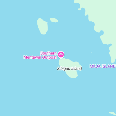
Exposed reefbreak near the southern tip of the Mentawi chain. Can get big and hollow becoming shifty. More challenging than other waves in the area
Surf spots nearby
- Rags Left (0.1 mi)
- Rags Right (2.2 mi)
- Greenbush (17.7 mi)
- Macaronis (22.2 mi)
- Silabu (24.9 mi)
Not Magic Seaweed (MSW)
Although we look a bit like Magic Seaweed we are not MagicSeaweed as they no longer exist...