Playa de Farama Surf Report
| Wave height * | 5.5ft / 1.7m |
|---|---|
| Swell period | 13s |
| Swell direction | |
| Wind | |
| Sea temp | 20°C / 69°F |

10 day Playa de Farama surf forecast
Mon
15/Dec
6ft
17
15
14
- Low 4:53am
- High 10:54am
- Low 5:07pm
- High 11:20pm
Tue
16/Dec
5.5ft
22
25
27
- Low 5:34am
- High 11:36am
- Low 5:43pm
- High 11:57pm
Wed
17/Dec
9.5ft
26
25
25
- Low 6:11am
- High 12:15pm
- Low 6:16pm
Thu
18/Dec
7ft
19
17
15
- High 12:32am
- Low 6:46am
- High 12:52pm
- Low 6:49pm
Fri
19/Dec
7ft
12
13
17
- High 1:06am
- Low 7:20am
- High 1:28pm
- Low 7:22pm
Sat
20/Dec
8ft
21
20
20
- High 1:41am
- Low 7:55am
- High 2:04pm
- Low 7:55pm
Sun
21/Dec
5.5ft
21
17
11
- High 2:16am
- Low 8:30am
- High 2:40pm
- Low 8:30pm
Mon
22/Dec
6.5ft
19
21
24
- High 2:51am
- Low 9:06am
- High 3:17pm
- Low 9:06pm
Tue
23/Dec
6.5ft
22
26
27
- High 3:29am
- Low 9:45am
- High 3:58pm
- Low 9:46pm
Wed
24/Dec
5.5ft
26
19
17
- High 4:11am
- Low 10:28am
Mon 15th Dec
| 3:00 | 5.5ft | 7.8ft | 10s | 17mph (19mph) | |||
| 6:00 | 5.5ft | 7.6ft | 10s | 17mph (19mph) | |||
| 9:00 | 6.5ft | 7.3ft | 12s | 17mph (19mph) | |||
| 12:00 | 6ft | 6.8ft | 12s | 15mph (16mph) | |||
| 15:00 | 5.5ft | 6.4ft | 13s | 14mph (17mph) | |||
| 18:00 | 5ft | 6ft | 13s | 14mph (14mph) | |||
| 21:00 | 5ft | 5.6ft | 13s | 15mph (17mph) |
| Tide times |
|---|
| Low 4:53am (0.83m) |
| High 10:54am (2.04m) |
| Low 5:07pm (0.74m) |
| High 11:20pm (2.14m) |
| Daylight | |
|---|---|
| First light | 07:14 |
| Sunrise | 07:40 |
| Sunset | 17:58 |
| Dark | 18:24 |
Tue 16th Dec
| 3:00 | 4.5ft | 5.4ft | 14s | 15mph (18mph) | |||
| 6:00 | 5.5ft | 6.1ft | 13s | 22mph (23mph) | |||
| 9:00 | 6ft | 6.4ft | 12s | 22mph (24mph) | |||
| 12:00 | 5.5ft | 7ft | 11s | 25mph (27mph) | |||
| 15:00 | 5.5ft | 8ft | 13s | 26mph (28mph) | |||
| 18:00 | 7.5ft | 9.6ft | 11s | 27mph (30mph) | |||
| 21:00 | 9ft | 11ft | 15s | 26mph (32mph) |
| Tide times |
|---|
| Low 5:34am (0.74m) |
| High 11:36am (2.08m) |
| Low 5:43pm (0.70m) |
| High 11:57pm (2.22m) |
| Daylight | |
|---|---|
| First light | 07:15 |
| Sunrise | 07:41 |
| Sunset | 17:58 |
| Dark | 18:24 |
Wed 17th Dec
| 3:00 | 10ft | 12.5ft | 14s | 24mph (29mph) | |||
| 6:00 | 10ft | 12.2ft | 13s | 26mph (29mph) | |||
| 9:00 | 9ft | 12.1ft | 13s | 28mph (33mph) | |||
| 12:00 | 9.5ft | 11.8ft | 12s | 25mph (30mph) | |||
| 15:00 | 8.5ft | 11.3ft | 12s | 23mph (26mph) | |||
| 18:00 | 8ft | 10.8ft | 12s | 25mph (28mph) | |||
| 21:00 | 7.5ft | 10.1ft | 12s | 24mph (26mph) |
| Tide times |
|---|
| Low 6:11am (0.67m) |
| High 12:15pm (2.11m) |
| Low 6:16pm (0.66m) |
| Daylight | |
|---|---|
| First light | 07:15 |
| Sunrise | 07:41 |
| Sunset | 17:59 |
| Dark | 18:25 |
Thu 18th Dec
| 3:00 | 8ft | 8.9ft | 12s | 20mph (21mph) | |||
| 6:00 | 7.5ft | 8.4ft | 11s | 19mph (21mph) | |||
| 9:00 | 7.5ft | 8ft | 11s | 18mph (19mph) | |||
| 12:00 | 7ft | 7.6ft | 11s | 17mph (18mph) | |||
| 15:00 | 7ft | 7.6ft | 11s | 13mph (13mph) | |||
| 18:00 | 7ft | 8ft | 23s | 15mph (15mph) | |||
| 21:00 | 7.5ft | 8.4ft | 21s | 12mph (14mph) |
| Tide times |
|---|
| High 12:32am (2.29m) |
| Low 6:46am (0.61m) |
| High 12:52pm (2.13m) |
| Low 6:49pm (0.64m) |
| Daylight | |
|---|---|
| First light | 07:16 |
| Sunrise | 07:42 |
| Sunset | 17:59 |
| Dark | 18:25 |
Fri 19th Dec
| 3:00 | 8ft | 8.6ft | 19s | 11mph (13mph) | |||
| 6:00 | 7.5ft | 8.2ft | 18s | 12mph (12mph) | |||
| 9:00 | 7.5ft | 8.1ft | 18s | 14mph (14mph) | |||
| 12:00 | 7ft | 7.9ft | 17s | 13mph (14mph) | |||
| 15:00 | 7ft | 7.9ft | 17s | 13mph (15mph) | |||
| 18:00 | 7ft | 7.9ft | 18s | 17mph (19mph) | |||
| 21:00 | 7ft | 8ft | 18s | 19mph (20mph) |
| Tide times |
|---|
| High 1:06am (2.34m) |
| Low 7:20am (0.57m) |
| High 1:28pm (2.14m) |
| Low 7:22pm (0.63m) |
| Daylight | |
|---|---|
| First light | 07:16 |
| Sunrise | 07:42 |
| Sunset | 17:59 |
| Dark | 18:25 |
Sat 20th Dec
| 3:00 | 7.5ft | 8.4ft | 18s | 19mph (21mph) | |||
| 6:00 | 7.5ft | 8.7ft | 18s | 21mph (20mph) | |||
| 9:00 | 7.5ft | 8.9ft | 17s | 17mph (18mph) | |||
| 12:00 | 8ft | 9.2ft | 17s | 20mph (20mph) | |||
| 15:00 | 8ft | 9.2ft | 17s | 18mph (20mph) | |||
| 18:00 | 7.5ft | 8.9ft | 16s | 20mph (21mph) | |||
| 21:00 | 7.5ft | 8.6ft | 16s | 20mph (23mph) |
| Tide times |
|---|
| High 1:41am (2.36m) |
| Low 7:55am (0.55m) |
| High 2:04pm (2.14m) |
| Low 7:55pm (0.63m) |
| Daylight | |
|---|---|
| First light | 07:17 |
| Sunrise | 07:43 |
| Sunset | 18:00 |
| Dark | 18:26 |
Sun 21st Dec
| 3:00 | 6.5ft | 7.9ft | 16s | 19mph (20mph) | |||
| 6:00 | 6ft | 7.5ft | 15s | 21mph (22mph) | |||
| 9:00 | 6ft | 7ft | 14s | 18mph (21mph) | |||
| 12:00 | 5.5ft | 6.5ft | 14s | 17mph (17mph) | |||
| 15:00 | 5ft | 6.1ft | 14s | 14mph (16mph) | |||
| 18:00 | 5ft | 6ft | 14s | 11mph (12mph) | |||
| 21:00 | 5ft | 6.3ft | 14s | 14mph (17mph) |
| Tide times |
|---|
| High 2:16am (2.36m) |
| Low 8:30am (0.55m) |
| High 2:40pm (2.12m) |
| Low 8:30pm (0.65m) |
| Daylight | |
|---|---|
| First light | 07:17 |
| Sunrise | 07:43 |
| Sunset | 18:00 |
| Dark | 18:26 |
Mon 22nd Dec
| 3:00 | 6.5ft | 7.9ft | 13s | 16mph (16mph) | |||
| 6:00 | 6.5ft | 8.1ft | 13s | 19mph (20mph) | |||
| 9:00 | 6.5ft | 8.1ft | 13s | 19mph (19mph) | |||
| 12:00 | 6.5ft | 8.1ft | 13s | 21mph (21mph) | |||
| 15:00 | 6.5ft | 8ft | 12s | 19mph (21mph) | |||
| 18:00 | 6.5ft | 8.1ft | 12s | 24mph (24mph) | |||
| 21:00 | 6.5ft | 8.3ft | 12s | 23mph (26mph) |
| Tide times |
|---|
| High 2:51am (2.35m) |
| Low 9:06am (0.57m) |
| High 3:17pm (2.08m) |
| Low 9:06pm (0.68m) |
| Daylight | |
|---|---|
| First light | 07:18 |
| Sunrise | 07:44 |
| Sunset | 18:01 |
| Dark | 18:27 |
Tue 23rd Dec
| 3:00 | 7.5ft | 8.9ft | 12s | 26mph (29mph) | |||
| 6:00 | 7ft | 9.1ft | 12s | 22mph (26mph) | |||
| 9:00 | 7ft | 9ft | 12s | 24mph (27mph) | |||
| 12:00 | 6.5ft | 8.8ft | 12s | 26mph (28mph) | |||
| 15:00 | 6.5ft | 8.5ft | 12s | 27mph (29mph) | |||
| 18:00 | 6.5ft | 8.4ft | 12s | 27mph (29mph) | |||
| 21:00 | 6ft | 8.2ft | 12s | 26mph (28mph) |
| Tide times |
|---|
| High 3:29am (2.31m) |
| Low 9:45am (0.61m) |
| High 3:58pm (2.04m) |
| Low 9:46pm (0.73m) |
| Daylight | |
|---|---|
| First light | 07:18 |
| Sunrise | 07:44 |
| Sunset | 18:01 |
| Dark | 18:27 |
Wed 24th Dec
| 3:00 | 6ft | 8.1ft | 12s | 27mph (29mph) | |||
| 6:00 | 6ft | 8ft | 12s | 26mph (28mph) | |||
| 9:00 | 6ft | 7.7ft | 11s | 23mph (24mph) | |||
| 12:00 | 5.5ft | 7.3ft | 11s | 19mph (18mph) | |||
| 15:00 | 5.5ft | 7ft | 11s | 16mph (18mph) | |||
| 18:00 | 5ft | 6.7ft | 11s | 17mph (18mph) | |||
| 21:00 | 5ft | 6.5ft | 11s | 20mph (20mph) |
| Tide times |
|---|
| High 4:11am (2.27m) |
| Low 10:28am (0.65m) |
| Daylight | |
|---|---|
| First light | 07:19 |
| Sunrise | 07:45 |
| Sunset | 18:02 |
| Dark | 18:28 |
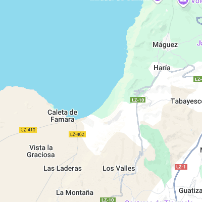
Long curving stretch of beach picking up plenty of swell. Suitable for all levels and no real localism. More exposed towards the N end but doesn't handle size too well and is often closey
Surf spots nearby
- Caleta de Famara (1.6 mi)
- San Juan (2.1 mi)
- Punta de Mujeres (5.3 mi)
- Caleta de Caballo Right (6 mi)
- Caleta de Caballo Left (6 mi)
- Jameos del Agua (7 mi)
- Boca del Abajo (7 mi)
- La Santa Right (7.5 mi)
- La Santa Left (7.6 mi)
- El Quemao (7.9 mi)
Not Magic Seaweed (MSW)
Although we look a bit like Magic Seaweed we are not MagicSeaweed as they no longer exist...