Wembury Bay Surf Report
| Wave height * | 6.5ft / 2m |
|---|---|
| Swell period | 16s |
| Swell direction | |
| Wind | |
| Sea temp | 12°C / 53°F |

10 day Wembury Bay surf forecast
Sat
20/Dec
6ft
25
26
28
- Low 12:07am
- High 6:13am
- Low 12:32pm
- High 6:33pm
Sun
21/Dec
6.5ft
8
8
11
- Low 12:43am
- High 6:51am
- Low 1:08pm
- High 7:12pm
Mon
22/Dec
3.5ft
16
13
11
- Low 1:19am
- High 7:29am
- Low 1:45pm
- High 7:52pm
Tue
23/Dec
2ft
7
8
9
- Low 1:56am
- High 8:07am
- Low 2:23pm
- High 8:30pm
Wed
24/Dec
4.5ft
21
27
30
- Low 2:34am
- High 8:43am
- Low 3:02pm
- High 9:07pm
Thu
25/Dec
3ft
25
22
19
- Low 3:14am
- High 9:19am
- Low 3:44pm
- High 9:45pm
Fri
26/Dec
2ft
21
21
22
- Low 3:58am
- High 9:59am
- Low 4:31pm
- High 10:30pm
Sat
27/Dec
4.5ft
25
26
24
- Low 4:49am
- High 10:49am
- Low 5:26pm
- High 11:27pm
Sun
28/Dec
2ft
21
21
22
- Low 5:51am
- High 11:53am
- Low 6:30pm
Mon
29/Dec
3.5ft
21
21
20
- High 12:40am
- Low 7:02am
- High 1:13pm
Sat 20th Dec
| 3:00 | 5ft | 8ft | 15s | 20mph (24mph) | |||
| 6:00 | 5.5ft | 8.3ft | 14s | 25mph (30mph) | |||
| 9:00 | 5.5ft | 8.6ft | 13s | 25mph (30mph) | |||
| 12:00 | 6ft | 9ft | 11s | 26mph (29mph) | |||
| 15:00 | 6ft | 9.5ft | 11s | 28mph (34mph) | |||
| 18:00 | 7.5ft | 10.9ft | 11s | 28mph (35mph) | |||
| 21:00 | 7ft | 10.1ft | 11s | 15mph (19mph) |
| Tide times |
|---|
| Low 12:07am (1.52m) |
| High 6:13am (5.38m) |
| Low 12:32pm (1.46m) |
| High 6:33pm (5.14m) |
| Daylight | |
|---|---|
| First light | 07:35 |
| Sunrise | 08:13 |
| Sunset | 16:15 |
| Dark | 16:54 |
Sun 21st Dec
| 3:00 | 6.5ft | 9.3ft | 16s | 13mph (15mph) | |||
| 6:00 | 6.5ft | 9.6ft | 16s | 8mph (10mph) | |||
| 9:00 | 6.5ft | 9.5ft | 16s | 10mph (13mph) | |||
| 12:00 | 6.5ft | 9.3ft | 16s | 8mph (9mph) | |||
| 15:00 | 6ft | 8.9ft | 15s | 7mph (13mph) | |||
| 18:00 | 5.5ft | 8.4ft | 15s | 11mph (16mph) | |||
| 21:00 | 5ft | 7.8ft | 15s | 11mph (18mph) |
| Tide times |
|---|
| Low 12:43am (1.49m) |
| High 6:51am (5.41m) |
| Low 1:08pm (1.42m) |
| High 7:12pm (5.12m) |
| Daylight | |
|---|---|
| First light | 07:35 |
| Sunrise | 08:14 |
| Sunset | 16:15 |
| Dark | 16:54 |
Mon 22nd Dec
| 3:00 | 4ft | 6.4ft | 15s | 3mph (6mph) | |||
| 6:00 | 4ft | 5.9ft | 14s | 16mph (22mph) | |||
| 9:00 | 3.5ft | 5.6ft | 14s | 15mph (20mph) | |||
| 12:00 | 3.5ft | 5.3ft | 13s | 13mph (17mph) | |||
| 15:00 | 3ft | 4.8ft | 13s | 11mph (15mph) | |||
| 18:00 | 3ft | 4.4ft | 13s | 11mph (17mph) | |||
| 21:00 | 2.5ft | 4.1ft | 12s | 6mph (7mph) |
| Tide times |
|---|
| Low 1:19am (1.51m) |
| High 7:29am (5.38m) |
| Low 1:45pm (1.43m) |
| High 7:52pm (5.05m) |
| Daylight | |
|---|---|
| First light | 07:35 |
| Sunrise | 08:14 |
| Sunset | 16:16 |
| Dark | 16:55 |
Tue 23rd Dec
| 3:00 | 2ft | 3.7ft | 12s | 9mph (11mph) | |||
| 6:00 | 2ft | 3.4ft | 11s | 7mph (8mph) | |||
| 9:00 | 2ft | 3.2ft | 11s | 6mph (9mph) | |||
| 12:00 | 2ft | 3.1ft | 11s | 8mph (12mph) | |||
| 15:00 | 2ft | 3.1ft | 11s | 10mph (15mph) | |||
| 18:00 | 2ft | 3.5ft | 13s | 9mph (17mph) | |||
| 21:00 | 2.5ft | 4ft | 14s | 13mph (27mph) |
| Tide times |
|---|
| Low 1:56am (1.56m) |
| High 8:07am (5.30m) |
| Low 2:23pm (1.49m) |
| High 8:30pm (4.93m) |
| Daylight | |
|---|---|
| First light | 07:36 |
| Sunrise | 08:15 |
| Sunset | 16:17 |
| Dark | 16:55 |
Wed 24th Dec
| 3:00 | 3ft | 4.7ft | 13s | 18mph (27mph) | |||
| 6:00 | 3ft | 5ft | 13s | 21mph (28mph) | |||
| 9:00 | 3.5ft | 5.5ft | 11s | 25mph (31mph) | |||
| 12:00 | 4.5ft | 6.4ft | 9s | 27mph (34mph) | |||
| 15:00 | 5.5ft | 7.2ft | 8s | 29mph (36mph) | |||
| 18:00 | 3.5ft | 8ft | 7s | 30mph (38mph) | |||
| 21:00 | 3.5ft | 8.4ft | 7s | 30mph (40mph) |
| Tide times |
|---|
| Low 2:34am (1.65m) |
| High 8:43am (5.18m) |
| Low 3:02pm (1.57m) |
| High 9:07pm (4.81m) |
| Daylight | |
|---|---|
| First light | 07:36 |
| Sunrise | 08:15 |
| Sunset | 16:17 |
| Dark | 16:56 |
Thu 25th Dec
| 3:00 | 3.5ft | 8ft | 8s | 27mph (35mph) | |||
| 6:00 | 3.5ft | 7.4ft | 8s | 25mph (33mph) | |||
| 9:00 | 3ft | 6.7ft | 8s | 23mph (33mph) | |||
| 12:00 | 3ft | 6.1ft | 7s | 22mph (30mph) | |||
| 15:00 | 2.5ft | 5.5ft | 7s | 17mph (22mph) | |||
| 18:00 | 2ft | 5.3ft | 6s | 19mph (26mph) | |||
| 21:00 | 1.5ft | 5.5ft | 6s | 20mph (28mph) |
| Tide times |
|---|
| Low 3:14am (1.76m) |
| High 9:19am (5.06m) |
| Low 3:44pm (1.67m) |
| High 9:45pm (4.71m) |
| Daylight | |
|---|---|
| First light | 07:36 |
| Sunrise | 08:15 |
| Sunset | 16:18 |
| Dark | 16:57 |
Fri 26th Dec
| 3:00 | 2ft | 6ft | 6s | 20mph (27mph) | |||
| 6:00 | 2ft | 6ft | 6s | 21mph (26mph) | |||
| 9:00 | 2ft | 6ft | 6s | 21mph (25mph) | |||
| 12:00 | 2ft | 6.1ft | 6s | 21mph (25mph) | |||
| 15:00 | 5ft | 6.4ft | 7s | 20mph (26mph) | |||
| 18:00 | 2.5ft | 6.9ft | 6s | 22mph (29mph) | |||
| 21:00 | 3ft | 7.6ft | 6s | 24mph (30mph) |
| Tide times |
|---|
| Low 3:58am (1.86m) |
| High 9:59am (4.96m) |
| Low 4:31pm (1.77m) |
| High 10:30pm (4.65m) |
| Daylight | |
|---|---|
| First light | 07:37 |
| Sunrise | 08:15 |
| Sunset | 16:19 |
| Dark | 16:57 |
Sat 27th Dec
| 3:00 | 3ft | 7.8ft | 7s | 25mph (32mph) | |||
| 6:00 | 5.5ft | 7ft | 9s | 25mph (32mph) | |||
| 9:00 | 5ft | 6.5ft | 9s | 27mph (35mph) | |||
| 12:00 | 4.5ft | 6ft | 8s | 26mph (34mph) | |||
| 15:00 | 4.5ft | 5.9ft | 8s | 25mph (32mph) | |||
| 18:00 | 3ft | 6.3ft | 6s | 24mph (31mph) | |||
| 21:00 | 3ft | 6.9ft | 7s | 23mph (30mph) |
| Tide times |
|---|
| Low 4:49am (1.95m) |
| High 10:49am (4.88m) |
| Low 5:26pm (1.85m) |
| High 11:27pm (4.63m) |
| Daylight | |
|---|---|
| First light | 07:37 |
| Sunrise | 08:15 |
| Sunset | 16:20 |
| Dark | 16:58 |
Sun 28th Dec
| 3:00 | 3ft | 7.4ft | 7s | 20mph (28mph) | |||
| 6:00 | 3ft | 7.2ft | 7s | 21mph (28mph) | |||
| 9:00 | 2.5ft | 6.6ft | 7s | 21mph (30mph) | |||
| 12:00 | 2ft | 5.9ft | 6s | 21mph (30mph) | |||
| 15:00 | 3.5ft | 4.9ft | 11s | 21mph (29mph) | |||
| 18:00 | 4ft | 5.1ft | 10s | 22mph (30mph) | |||
| 21:00 | 3.5ft | 4.3ft | 9s | 22mph (30mph) |
| Tide times |
|---|
| Low 5:51am (2.02m) |
| High 11:53am (4.82m) |
| Low 6:30pm (1.89m) |
| Daylight | |
|---|---|
| First light | 07:37 |
| Sunrise | 08:16 |
| Sunset | 16:20 |
| Dark | 16:59 |
Mon 29th Dec
| 3:00 | 2.5ft | 3.6ft | 13s | 18mph (27mph) | |||
| 6:00 | 2.5ft | 3.6ft | 13s | 21mph (30mph) | |||
| 9:00 | 3ft | 4.1ft | 7s | 22mph (31mph) | |||
| 12:00 | 3.5ft | 4.5ft | 6s | 21mph (28mph) | |||
| 15:00 | 3.5ft | 5.9ft | 6s | 21mph (27mph) | |||
| 18:00 | 4ft | 8ft | 7s | 20mph (29mph) | |||
| 21:00 | 4ft | 7.7ft | 7s | 19mph (28mph) |
| Tide times |
|---|
| High 12:40am (4.67m) |
| Low 7:02am (2.01m) |
| High 1:13pm (4.82m) |
| Daylight | |
|---|---|
| First light | 07:37 |
| Sunrise | 08:16 |
| Sunset | 16:21 |
| Dark | 17:00 |
Nearest buoys
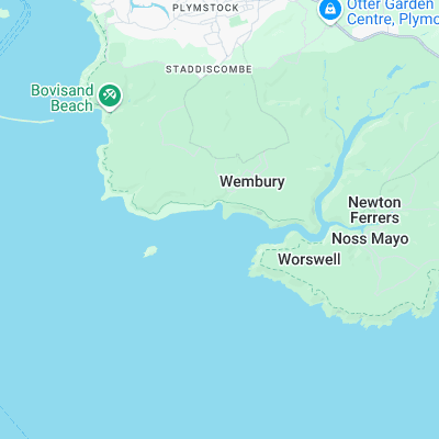
Lefthand point breaking off Blackstone Rocks. Can line up to form a long walling wave over the rock/sand bottom. Needs a big swell to work but can hold a fair size wave. Proximity to Plymouth means it can get busy. There’s also a righthander further up the beach breaking on the sandbar at the mouth of the River Yealm
Surf spots nearby
- Bovisand (2.3 mi)
- Mothecombe (5.9 mi)
- Whitsand Bay (7.4 mi)
- Challabrough (8.3 mi)
- Bantham (9.1 mi)
- Thurlestone (10.1 mi)
- Portwrinkle (10.4 mi)
- Hope Cove (10.8 mi)
- Seaton (13.7 mi)
- Salcombe (14.7 mi)
Not Magic Seaweed (MSW)
Although we look a bit like Magic Seaweed we are not MagicSeaweed as they no longer exist...