Playa de la Canteria Surf Report
| Wave height * | 6ft / 1.8m |
|---|---|
| Swell period | 16s |
| Swell direction | |
| Wind | |
| Sea temp | 19°C / 66°F |

10 day Playa de la Canteria surf forecast
Fri
30/Jan
5.5ft
11
14
16
- Low 6:12am
- High 12:21pm
- Low 6:21pm
Sat
31/Jan
5.5ft
18
16
15
- High 12:36am
- Low 6:57am
- High 1:06pm
- Low 7:04pm
Sun
1/Feb
5ft
16
12
7
- High 1:19am
- Low 7:39am
- High 1:47pm
- Low 7:43pm
Mon
2/Feb
4.5ft
18
23
25
- High 1:59am
- Low 8:17am
- High 2:25pm
- Low 8:20pm
Tue
3/Feb
7.5ft
18
16
12
- High 2:37am
- Low 8:53am
- High 3:02pm
- Low 8:56pm
Wed
4/Feb
6.5ft
11
8
7
- High 3:14am
- Low 9:28am
- High 3:38pm
- Low 9:30pm
Thu
5/Feb
5.5ft
7
5
7
- High 3:50am
- Low 10:01am
- High 4:13pm
- Low 10:06pm
Fri
6/Feb
6ft
6
10
19
- High 4:26am
- Low 10:35am
- High 4:50pm
- Low 10:43pm
Sat
7/Feb
5ft
21
22
17
- High 5:05am
- Low 11:11am
- High 5:32pm
- Low 11:26pm
Sun
8/Feb
6ft
20
13
14
- High 5:51am
- Low 11:55am
Fri 30th Jan
| 3:00 | 6ft | 9.1ft | 15s | 14mph (16mph) | |||
| 6:00 | 6ft | 8.6ft | 14s | 11mph (11mph) | |||
| 9:00 | 5.5ft | 8.5ft | 14s | 10mph (11mph) | |||
| 12:00 | 5.5ft | 8.7ft | 14s | 14mph (17mph) | |||
| 15:00 | 6.5ft | 9.7ft | 14s | 15mph (18mph) | |||
| 18:00 | 7ft | 10.5ft | 19s | 16mph (18mph) | |||
| 21:00 | 7ft | 10.6ft | 18s | 13mph (17mph) |
| Tide times |
|---|
| Low 6:12am (0.44m) |
| High 12:21pm (2.26m) |
| Low 6:21pm (0.52m) |
| Daylight | |
|---|---|
| First light | 07:18 |
| Sunrise | 07:43 |
| Sunset | 18:31 |
| Dark | 18:56 |
Sat 31st Jan
| 3:00 | 6ft | 9.8ft | 16s | 15mph (19mph) | |||
| 6:00 | 5.5ft | 9.2ft | 16s | 18mph (22mph) | |||
| 9:00 | 5.5ft | 9.1ft | 15s | 16mph (21mph) | |||
| 12:00 | 5.5ft | 8.9ft | 15s | 16mph (20mph) | |||
| 15:00 | 5.5ft | 8.8ft | 15s | 16mph (19mph) | |||
| 18:00 | 5.5ft | 8.7ft | 15s | 15mph (18mph) | |||
| 21:00 | 5.5ft | 8.7ft | 14s | 18mph (21mph) |
| Tide times |
|---|
| High 12:36am (2.55m) |
| Low 6:57am (0.31m) |
| High 1:06pm (2.36m) |
| Low 7:04pm (0.42m) |
| Daylight | |
|---|---|
| First light | 07:17 |
| Sunrise | 07:42 |
| Sunset | 18:32 |
| Dark | 18:56 |
Sun 1st Feb
| 3:00 | 6ft | 8.7ft | 15s | 17mph (19mph) | |||
| 6:00 | 5.5ft | 8.6ft | 14s | 16mph (18mph) | |||
| 9:00 | 5ft | 8.3ft | 14s | 14mph (16mph) | |||
| 12:00 | 5ft | 7.9ft | 13s | 12mph (13mph) | |||
| 15:00 | 4.5ft | 7.6ft | 13s | 10mph (11mph) | |||
| 18:00 | 4.5ft | 7.1ft | 13s | 7mph (9mph) | |||
| 21:00 | 4ft | 6.7ft | 13s | 7mph (9mph) |
| Tide times |
|---|
| High 1:19am (2.65m) |
| Low 7:39am (0.24m) |
| High 1:47pm (2.41m) |
| Low 7:43pm (0.37m) |
| Daylight | |
|---|---|
| First light | 07:17 |
| Sunrise | 07:42 |
| Sunset | 18:32 |
| Dark | 18:57 |
Mon 2nd Feb
| 3:00 | 4ft | 6.3ft | 13s | 12mph (15mph) | |||
| 6:00 | 4ft | 6.3ft | 12s | 18mph (21mph) | |||
| 9:00 | 4ft | 6.3ft | 12s | 17mph (23mph) | |||
| 12:00 | 4.5ft | 6.4ft | 12s | 23mph (28mph) | |||
| 15:00 | 4.5ft | 7.4ft | 14s | 23mph (26mph) | |||
| 18:00 | 5.5ft | 9ft | 13s | 25mph (27mph) | |||
| 21:00 | 7ft | 10.3ft | 13s | 22mph (25mph) |
| Tide times |
|---|
| High 1:59am (2.69m) |
| Low 8:17am (0.23m) |
| High 2:25pm (2.41m) |
| Low 8:20pm (0.37m) |
| Daylight | |
|---|---|
| First light | 07:16 |
| Sunrise | 07:41 |
| Sunset | 18:33 |
| Dark | 18:58 |
Tue 3rd Feb
| 3:00 | 7.5ft | 10.9ft | 13s | 19mph (23mph) | |||
| 6:00 | 7.5ft | 11.4ft | 13s | 18mph (22mph) | |||
| 9:00 | 8ft | 11.6ft | 13s | 19mph (20mph) | |||
| 12:00 | 7.5ft | 11.5ft | 13s | 16mph (17mph) | |||
| 15:00 | 7ft | 11.4ft | 13s | 14mph (14mph) | |||
| 18:00 | 8ft | 11.8ft | 14s | 12mph (13mph) | |||
| 21:00 | 8ft | 12ft | 17s | 8mph (8mph) |
| Tide times |
|---|
| High 2:37am (2.67m) |
| Low 8:53am (0.28m) |
| High 3:02pm (2.37m) |
| Low 8:56pm (0.42m) |
| Daylight | |
|---|---|
| First light | 07:16 |
| Sunrise | 07:40 |
| Sunset | 18:34 |
| Dark | 18:59 |
Wed 4th Feb
| 3:00 | 7.5ft | 11.5ft | 15s | 11mph (12mph) | |||
| 6:00 | 7.5ft | 11ft | 15s | 11mph (12mph) | |||
| 9:00 | 7ft | 10.4ft | 14s | 11mph (12mph) | |||
| 12:00 | 6.5ft | 9.9ft | 14s | 8mph (9mph) | |||
| 15:00 | 6.5ft | 9.4ft | 14s | 8mph (8mph) | |||
| 18:00 | 6ft | 9.1ft | 13s | 7mph (8mph) | |||
| 21:00 | 6ft | 8.9ft | 13s | 6mph (7mph) |
| Tide times |
|---|
| High 3:14am (2.58m) |
| Low 9:28am (0.37m) |
| High 3:38pm (2.29m) |
| Low 9:30pm (0.51m) |
| Daylight | |
|---|---|
| First light | 07:15 |
| Sunrise | 07:40 |
| Sunset | 18:35 |
| Dark | 19:00 |
Thu 5th Feb
| 3:00 | 5.5ft | 8.1ft | 12s | 6mph (7mph) | |||
| 6:00 | 5.5ft | 8ft | 12s | 7mph (8mph) | |||
| 9:00 | 5.5ft | 8ft | 17s | 6mph (7mph) | |||
| 12:00 | 5.5ft | 8.2ft | 18s | 5mph (7mph) | |||
| 15:00 | 5ft | 8.7ft | 20s | 4mph (5mph) | |||
| 18:00 | 5.5ft | 9.3ft | 19s | 7mph (8mph) | |||
| 21:00 | 5.5ft | 9.8ft | 18s | 7mph (8mph) |
| Tide times |
|---|
| High 3:50am (2.45m) |
| Low 10:01am (0.51m) |
| High 4:13pm (2.18m) |
| Low 10:06pm (0.64m) |
| Daylight | |
|---|---|
| First light | 07:14 |
| Sunrise | 07:39 |
| Sunset | 18:36 |
| Dark | 19:00 |
Fri 6th Feb
| 3:00 | 6ft | 10.7ft | 17s | 9mph (11mph) | |||
| 6:00 | 6ft | 10.5ft | 17s | 6mph (7mph) | |||
| 9:00 | 6ft | 10.4ft | 16s | 8mph (9mph) | |||
| 12:00 | 6ft | 10.3ft | 16s | 10mph (12mph) | |||
| 15:00 | 6ft | 10.2ft | 16s | 15mph (18mph) | |||
| 18:00 | 5.5ft | 10.1ft | 16s | 19mph (23mph) | |||
| 21:00 | 5.5ft | 9.7ft | 15s | 20mph (23mph) |
| Tide times |
|---|
| High 4:26am (2.28m) |
| Low 10:35am (0.66m) |
| High 4:50pm (2.06m) |
| Low 10:43pm (0.79m) |
| Daylight | |
|---|---|
| First light | 07:14 |
| Sunrise | 07:38 |
| Sunset | 18:37 |
| Dark | 19:01 |
Sat 7th Feb
| 3:00 | 4.5ft | 9.1ft | 14s | 18mph (20mph) | |||
| 6:00 | 4.5ft | 9.2ft | 14s | 21mph (23mph) | |||
| 9:00 | 4.5ft | 9.1ft | 14s | 23mph (25mph) | |||
| 12:00 | 5ft | 8.8ft | 13s | 22mph (24mph) | |||
| 15:00 | 5ft | 9.1ft | 13s | 22mph (24mph) | |||
| 18:00 | 5ft | 9.1ft | 13s | 17mph (19mph) | |||
| 21:00 | 5ft | 8.8ft | 13s | 24mph (27mph) |
| Tide times |
|---|
| High 5:05am (2.09m) |
| Low 11:11am (0.82m) |
| High 5:32pm (1.94m) |
| Low 11:26pm (0.94m) |
| Daylight | |
|---|---|
| First light | 07:13 |
| Sunrise | 07:38 |
| Sunset | 18:37 |
| Dark | 19:02 |
Sun 8th Feb
| 3:00 | 5.5ft | 9ft | 12s | 18mph (22mph) | |||
| 6:00 | 6ft | 9.1ft | 13s | 20mph (22mph) | |||
| 9:00 | 6ft | 8.9ft | 14s | 17mph (18mph) | |||
| 12:00 | 6ft | 8.7ft | 15s | 13mph (14mph) | |||
| 15:00 | 5.5ft | 8.4ft | 14s | 12mph (13mph) | |||
| 18:00 | 5.5ft | 8ft | 14s | 14mph (15mph) | |||
| 21:00 | 5ft | 7.5ft | 13s | 12mph (13mph) |
| Tide times |
|---|
| High 5:51am (1.90m) |
| Low 11:55am (0.97m) |
| Daylight | |
|---|---|
| First light | 07:12 |
| Sunrise | 07:37 |
| Sunset | 18:38 |
| Dark | 19:03 |
Relatively sheltered cove at the northern end of Lanzarote. Reasonably consistent peaks at mid-high but tends to close out on lower tides and bigger swells
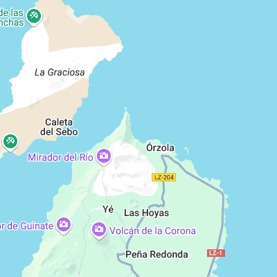
Surf spots nearby
- La Graciosa (3.9 mi)
- Golden Eye (4.6 mi)
- Jameos del Agua (5.4 mi)
- Punta de Mujeres (6.1 mi)
- Playa de Farama (8.3 mi)
- San Juan (9.5 mi)
- Caleta de Famara (9.6 mi)
- Caleta de Caballo Right (12.9 mi)
- Caleta de Caballo Left (12.9 mi)
- Boca del Abajo (13.6 mi)
Not Magic Seaweed (MSW)
Although we look a bit like Magic Seaweed we are not MagicSeaweed as they no longer exist...