Carbis Bay Surf Report
| Wave height * | 2.5ft / 0.7m |
|---|---|
| Swell period | 7s |
| Swell direction | |
| Wind | |
| Sea temp | 10°C / 51°F |

10 day Carbis Bay surf forecast
Tue
6/Jan
2.5ft
10
17
26
- Low 12:53am
- High 6:28am
- Low 1:23pm
- High 6:52pm
Wed
7/Jan
4.5ft
24
16
15
- Low 1:37am
- High 7:11am
- Low 2:07pm
- High 7:35pm
Thu
8/Jan
3ft
10
9
29
- Low 2:18am
- High 7:53am
- Low 2:48pm
- High 8:17pm
Fri
9/Jan
5ft
36
31
29
- Low 2:58am
- High 8:35am
- Low 3:28pm
- High 8:59pm
Sat
10/Jan
4ft
27
17
4
- Low 3:39am
- High 9:19am
- Low 4:11pm
- High 9:46pm
Sun
11/Jan
2.5ft
32
39
15
- Low 4:24am
- High 10:08am
- Low 5:00pm
- High 10:42pm
Mon
12/Jan
5ft
17
25
28
- Low 5:20am
- High 11:10am
- Low 5:59pm
- High 11:52pm
Tue
13/Jan
5ft
13
12
11
- Low 6:29am
- High 12:26pm
- Low 7:08pm
Wed
14/Jan
4.5ft
14
30
28
- High 1:08am
- Low 7:42am
- High 1:39pm
- Low 8:15pm
Thu
15/Jan
5ft
32
22
19
- High 2:12am
- Low 8:47am
- High 2:38pm
- Low 9:11pm
Tue 6th Jan
| 3:00 | 3.5ft | 4.7ft | 6s | 13mph (17mph) | |||
| 6:00 | 3.5ft | 4.2ft | 6s | 10mph (13mph) | |||
| 9:00 | 2.5ft | 3.7ft | 6s | 11mph (15mph) | |||
| 12:00 | 2.5ft | 3.5ft | 5s | 17mph (20mph) | |||
| 15:00 | 2ft | 4.4ft | 5s | 22mph (27mph) | |||
| 18:00 | 2ft | 6.1ft | 6s | 26mph (32mph) | |||
| 21:00 | 2.5ft | 6.9ft | 7s | 18mph (24mph) |
| Tide times |
|---|
| Low 12:53am (0.88m) |
| High 6:28am (5.69m) |
| Low 1:23pm (0.79m) |
| High 6:52pm (5.33m) |
| Daylight | |
|---|---|
| First light | 07:42 |
| Sunrise | 08:20 |
| Sunset | 16:35 |
| Dark | 17:13 |
Wed 7th Jan
| 3:00 | 3.5ft | 8ft | 7s | 26mph (31mph) | |||
| 6:00 | 4.5ft | 8.1ft | 7s | 24mph (30mph) | |||
| 9:00 | 4.5ft | 7.8ft | 7s | 21mph (27mph) | |||
| 12:00 | 4.5ft | 7ft | 7s | 16mph (21mph) | |||
| 15:00 | 4ft | 6.4ft | 7s | 9mph (13mph) | |||
| 18:00 | 4ft | 6.3ft | 8s | 15mph (32mph) | |||
| 21:00 | 3.5ft | 7.1ft | 7s | 20mph (30mph) |
| Tide times |
|---|
| Low 1:37am (0.98m) |
| High 7:11am (5.56m) |
| Low 2:07pm (0.94m) |
| High 7:35pm (5.16m) |
| Daylight | |
|---|---|
| First light | 07:41 |
| Sunrise | 08:19 |
| Sunset | 16:36 |
| Dark | 17:14 |
Thu 8th Jan
| 3:00 | 3ft | 7.5ft | 8s | 15mph (20mph) | |||
| 6:00 | 2.5ft | 7ft | 8s | 10mph (13mph) | |||
| 9:00 | 2.5ft | 6.5ft | 9s | 5mph (7mph) | |||
| 12:00 | 3ft | 8.5ft | 8s | 9mph (33mph) | |||
| 15:00 | 3.5ft | 13.9ft | 9s | 32mph (48mph) | |||
| 18:00 | 3.5ft | 14ft | 11s | 29mph (46mph) | |||
| 21:00 | 11.5ft | 18.6ft | 10s | 51mph (52mph) |
| Tide times |
|---|
| Low 2:18am (1.16m) |
| High 7:53am (5.35m) |
| Low 2:48pm (1.17m) |
| High 8:17pm (4.95m) |
| Daylight | |
|---|---|
| First light | 07:41 |
| Sunrise | 08:19 |
| Sunset | 16:37 |
| Dark | 17:15 |
Fri 9th Jan
| 3:00 | 9ft | 15.5ft | 11s | 37mph (47mph) | |||
| 6:00 | 4.5ft | 14.4ft | 11s | 36mph (43mph) | |||
| 9:00 | 4ft | 13.2ft | 12s | 33mph (40mph) | |||
| 12:00 | 5ft | 14.3ft | 12s | 31mph (38mph) | |||
| 15:00 | 5.5ft | 15.3ft | 12s | 38mph (49mph) | |||
| 18:00 | 5.5ft | 15.6ft | 13s | 29mph (36mph) | |||
| 21:00 | 6ft | 14.2ft | 12s | 31mph (38mph) |
| Tide times |
|---|
| Low 2:58am (1.39m) |
| High 8:35am (5.09m) |
| Low 3:28pm (1.44m) |
| High 8:59pm (4.72m) |
| Daylight | |
|---|---|
| First light | 07:41 |
| Sunrise | 08:18 |
| Sunset | 16:39 |
| Dark | 17:16 |
Sat 10th Jan
| 3:00 | 6ft | 14.2ft | 13s | 33mph (41mph) | |||
| 6:00 | 5.5ft | 13.1ft | 12s | 27mph (33mph) | |||
| 9:00 | 4.5ft | 11.5ft | 12s | 22mph (28mph) | |||
| 12:00 | 4ft | 9.8ft | 12s | 17mph (21mph) | |||
| 15:00 | 3.5ft | 8.5ft | 11s | 10mph (12mph) | |||
| 18:00 | 3ft | 7.6ft | 11s | 4mph (4mph) | |||
| 21:00 | 3ft | 6.9ft | 11s | 9mph (10mph) |
| Tide times |
|---|
| Low 3:39am (1.64m) |
| High 9:19am (4.81m) |
| Low 4:11pm (1.71m) |
| High 9:46pm (4.50m) |
| Daylight | |
|---|---|
| First light | 07:40 |
| Sunrise | 08:18 |
| Sunset | 16:40 |
| Dark | 17:17 |
Sun 11th Jan
| 3:00 | 3ft | 9.1ft | 7s | 25mph (33mph) | |||
| 6:00 | 2.5ft | 11.4ft | 8s | 32mph (43mph) | |||
| 9:00 | 3ft | 11.7ft | 9s | 39mph (52mph) | |||
| 12:00 | 2.5ft | 10.7ft | 10s | 39mph (52mph) | |||
| 15:00 | 2.5ft | 10.4ft | 10s | 31mph (43mph) | |||
| 18:00 | 2.5ft | 10.8ft | 10s | 15mph (26mph) | |||
| 21:00 | 3ft | 11.6ft | 10s | 19mph (29mph) |
| Tide times |
|---|
| Low 4:24am (1.89m) |
| High 10:08am (4.54m) |
| Low 5:00pm (1.94m) |
| High 10:42pm (4.31m) |
| Daylight | |
|---|---|
| First light | 07:40 |
| Sunrise | 08:17 |
| Sunset | 16:41 |
| Dark | 17:19 |
Mon 12th Jan
| 3:00 | 4.5ft | 12.8ft | 12s | 16mph (25mph) | |||
| 6:00 | 4.5ft | 12.7ft | 12s | 17mph (27mph) | |||
| 9:00 | 4.5ft | 12.9ft | 12s | 20mph (31mph) | |||
| 12:00 | 5ft | 13.4ft | 13s | 25mph (36mph) | |||
| 15:00 | 5.5ft | 13.7ft | 14s | 28mph (40mph) | |||
| 18:00 | 5.5ft | 13.8ft | 14s | 28mph (42mph) | |||
| 21:00 | 5.5ft | 14.1ft | 14s | 16mph (26mph) |
| Tide times |
|---|
| Low 5:20am (2.10m) |
| High 11:10am (4.31m) |
| Low 5:59pm (2.10m) |
| High 11:52pm (4.21m) |
| Daylight | |
|---|---|
| First light | 07:39 |
| Sunrise | 08:17 |
| Sunset | 16:43 |
| Dark | 17:20 |
Tue 13th Jan
| 3:00 | 5.5ft | 13.1ft | 13s | 13mph (21mph) | |||
| 6:00 | 5.5ft | 13.4ft | 13s | 13mph (23mph) | |||
| 9:00 | 5ft | 13.6ft | 12s | 19mph (21mph) | |||
| 12:00 | 5ft | 13.7ft | 12s | 12mph (17mph) | |||
| 15:00 | 4ft | 13.5ft | 12s | 11mph (16mph) | |||
| 18:00 | 4.5ft | 12.8ft | 13s | 11mph (16mph) | |||
| 21:00 | 5.5ft | 13.1ft | 14s | 10mph (14mph) |
| Tide times |
|---|
| Low 6:29am (2.20m) |
| High 12:26pm (4.20m) |
| Low 7:08pm (2.14m) |
| Daylight | |
|---|---|
| First light | 07:39 |
| Sunrise | 08:16 |
| Sunset | 16:44 |
| Dark | 17:21 |
Wed 14th Jan
| 3:00 | 5ft | 12.4ft | 12s | 12mph (18mph) | |||
| 6:00 | 5ft | 12.2ft | 12s | 14mph (22mph) | |||
| 9:00 | 3.5ft | 13.9ft | 9s | 21mph (30mph) | |||
| 12:00 | 4.5ft | 15.3ft | 10s | 30mph (40mph) | |||
| 15:00 | 6ft | 16.3ft | 11s | 32mph (48mph) | |||
| 18:00 | 6ft | 17.1ft | 11s | 28mph (43mph) | |||
| 21:00 | 7ft | 17.6ft | 12s | 31mph (46mph) |
| Tide times |
|---|
| High 1:08am (4.26m) |
| Low 7:42am (2.17m) |
| High 1:39pm (4.26m) |
| Low 8:15pm (2.05m) |
| Daylight | |
|---|---|
| First light | 07:38 |
| Sunrise | 08:15 |
| Sunset | 16:46 |
| Dark | 17:23 |
Thu 15th Jan
| 3:00 | 6ft | 15ft | 13s | 35mph (51mph) | |||
| 6:00 | 5.5ft | 13.8ft | 13s | 32mph (42mph) | |||
| 9:00 | 5ft | 12.8ft | 13s | 20mph (29mph) | |||
| 12:00 | 5ft | 12.1ft | 13s | 22mph (26mph) | |||
| 15:00 | 4.5ft | 11.5ft | 13s | 20mph (26mph) | |||
| 18:00 | 4.5ft | 11.2ft | 13s | 19mph (27mph) | |||
| 21:00 | 4.5ft | 10.9ft | 13s | 20mph (27mph) |
| Tide times |
|---|
| High 2:12am (4.44m) |
| Low 8:47am (2.00m) |
| High 2:38pm (4.42m) |
| Low 9:11pm (1.87m) |
| Daylight | |
|---|---|
| First light | 07:38 |
| Sunrise | 08:14 |
| Sunset | 16:47 |
| Dark | 17:24 |
Nearest buoys
Beach break that takes a huge north coast swell to work. Reasonably sheltered from westerly winds
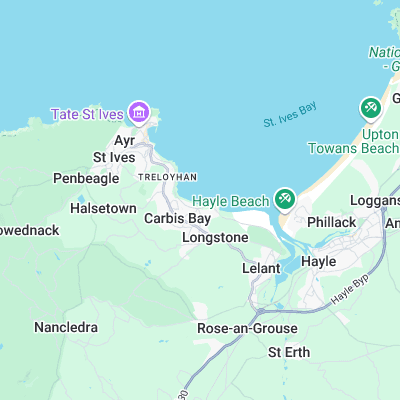
Surf spots nearby
- Hawks Point (0.4 mi)
- The Breakwater (1.3 mi)
- Porthmeor (1.6 mi)
- Sandy Acres (2.2 mi)
- Hayle Towans (2.4 mi)
- Gwithian (3.3 mi)
- Godrevy (3.8 mi)
- Marazion (5.2 mi)
- Danger Bay (6 mi)
- Perranuthnoe (6 mi)
Not Magic Seaweed (MSW)
Although we look a bit like Magic Seaweed we are not MagicSeaweed as they no longer exist...