Perranuthnoe Surf Report
| Wave height * | 2ft / 0.6m |
|---|---|
| Swell period | 15s |
| Swell direction | |
| Wind | |
| Sea temp | 11°C / 52°F |

10 day Perranuthnoe surf forecast
Thu
1/Jan
2ft
14
13
19
- High 2:16am
- Low 8:58am
- High 2:47pm
- Low 9:25pm
Fri
2/Jan
0.5ft
20
23
21
- High 3:15am
- Low 9:59am
- High 3:43pm
- Low 10:23pm
Sat
3/Jan
1ft
23
23
19
- High 4:08am
- Low 10:56am
- High 4:34pm
- Low 11:16pm
Sun
4/Jan
0.5ft
16
7
14
- High 4:57am
- Low 11:48am
- High 5:22pm
Mon
5/Jan
1.5ft
13
16
15
- Low 12:06am
- High 5:43am
- Low 12:37pm
- High 6:08pm
Tue
6/Jan
1.5ft
12
15
7
- Low 12:53am
- High 6:28am
- Low 1:23pm
- High 6:52pm
Wed
7/Jan
2.5ft
7
20
24
- Low 1:37am
- High 7:11am
- Low 2:07pm
- High 7:35pm
Thu
8/Jan
5ft
16
37
23
- Low 2:18am
- High 7:53am
- Low 2:48pm
- High 8:17pm
Fri
9/Jan
9ft
26
17
7
- Low 2:58am
- High 8:35am
- Low 3:28pm
- High 8:59pm
Sat
10/Jan
5ft
16
14
13
- Low 3:39am
- High 9:19am
- Low 4:11pm
Thu 1st Jan
| 3:00 | 1.5ft | 2.5ft | 12s | 4mph (7mph) | |||
| 6:00 | 1.5ft | 2.6ft | 13s | 14mph (16mph) | |||
| 9:00 | 2ft | 3ft | 11s | 16mph (18mph) | |||
| 12:00 | 2ft | 3.3ft | 15s | 13mph (15mph) | |||
| 15:00 | 2ft | 3.3ft | 15s | 16mph (18mph) | |||
| 18:00 | 0.5ft | 4.1ft | 8s | 19mph (22mph) | |||
| 21:00 | 0.5ft | 4.1ft | 8s | 15mph (16mph) |
| Tide times |
|---|
| High 2:16am (4.94m) |
| Low 8:58am (1.42m) |
| High 2:47pm (5.04m) |
| Low 9:25pm (1.31m) |
| Daylight | |
|---|---|
| First light | 07:42 |
| Sunrise | 08:20 |
| Sunset | 16:30 |
| Dark | 17:08 |
Fri 2nd Jan
| 3:00 | 2ft | 3.7ft | 13s | 16mph (18mph) | |||
| 6:00 | 0.5ft | 3.9ft | 11s | 20mph (22mph) | |||
| 9:00 | 0.5ft | 4.3ft | 10s | 21mph (23mph) | |||
| 12:00 | 0.5ft | 5ft | 8s | 23mph (25mph) | |||
| 15:00 | 1ft | 5.4ft | 8s | 23mph (24mph) | |||
| 18:00 | 0.5ft | 5.1ft | 8s | 21mph (22mph) | |||
| 21:00 | 0.5ft | 4.8ft | 8s | 18mph (20mph) |
| Tide times |
|---|
| High 3:15am (5.22m) |
| Low 9:59am (1.16m) |
| High 3:43pm (5.24m) |
| Low 10:23pm (1.11m) |
| Daylight | |
|---|---|
| First light | 07:42 |
| Sunrise | 08:20 |
| Sunset | 16:31 |
| Dark | 17:09 |
Sat 3rd Jan
| 3:00 | 0.5ft | 5.4ft | 8s | 20mph (21mph) | |||
| 6:00 | 0.5ft | 6.1ft | 8s | 23mph (25mph) | |||
| 9:00 | 0.5ft | 6.3ft | 9s | 24mph (26mph) | |||
| 12:00 | 1ft | 6.4ft | 9s | 23mph (24mph) | |||
| 15:00 | 0.5ft | 5.9ft | 9s | 20mph (23mph) | |||
| 18:00 | 0.5ft | 5.9ft | 8s | 19mph (22mph) | |||
| 21:00 | 0.5ft | 5.6ft | 8s | 20mph (22mph) |
| Tide times |
|---|
| High 4:08am (5.48m) |
| Low 10:56am (0.94m) |
| High 4:34pm (5.39m) |
| Low 11:16pm (0.96m) |
| Daylight | |
|---|---|
| First light | 07:42 |
| Sunrise | 08:20 |
| Sunset | 16:32 |
| Dark | 17:10 |
Sun 4th Jan
| 3:00 | 0.5ft | 4.8ft | 8s | 14mph (17mph) | |||
| 6:00 | 0.5ft | 4.6ft | 8s | 16mph (16mph) | |||
| 9:00 | 0.5ft | 4.3ft | 7s | 13mph (16mph) | |||
| 12:00 | 0.5ft | 3.9ft | 7s | 7mph (10mph) | |||
| 15:00 | 0.5ft | 3.7ft | 8s | 11mph (14mph) | |||
| 18:00 | 0.5ft | 3.7ft | 8s | 14mph (15mph) | |||
| 21:00 | 0.5ft | 3.5ft | 10s | 12mph (13mph) |
| Tide times |
|---|
| High 4:57am (5.65m) |
| Low 11:48am (0.79m) |
| High 5:22pm (5.45m) |
| Daylight | |
|---|---|
| First light | 07:42 |
| Sunrise | 08:20 |
| Sunset | 16:33 |
| Dark | 17:11 |
Mon 5th Jan
| 3:00 | 2ft | 3.1ft | 12s | 12mph (12mph) | |||
| 6:00 | 1.5ft | 2.9ft | 12s | 13mph (13mph) | |||
| 9:00 | 1.5ft | 2.7ft | 12s | 14mph (14mph) | |||
| 12:00 | 1.5ft | 2.4ft | 11s | 16mph (16mph) | |||
| 15:00 | 1.5ft | 2.5ft | 11s | 19mph (20mph) | |||
| 18:00 | 0.5ft | 3.4ft | 7s | 15mph (19mph) | |||
| 21:00 | 0.5ft | 3.8ft | 7s | 17mph (17mph) |
| Tide times |
|---|
| Low 12:06am (0.88m) |
| High 5:43am (5.72m) |
| Low 12:37pm (0.73m) |
| High 6:08pm (5.43m) |
| Daylight | |
|---|---|
| First light | 07:42 |
| Sunrise | 08:19 |
| Sunset | 16:34 |
| Dark | 17:12 |
Tue 6th Jan
| 3:00 | 0.5ft | 3ft | 8s | 10mph (9mph) | |||
| 6:00 | 1ft | 2.8ft | 7s | 12mph (11mph) | |||
| 9:00 | 1.5ft | 2.7ft | 11s | 16mph (15mph) | |||
| 12:00 | 1.5ft | 2.6ft | 10s | 15mph (15mph) | |||
| 15:00 | 1.5ft | 2.7ft | 8s | 10mph (11mph) | |||
| 18:00 | 2ft | 3.1ft | 7s | 7mph (7mph) | |||
| 21:00 | 2ft | 3.4ft | 6s | 9mph (9mph) |
| Tide times |
|---|
| Low 12:53am (0.88m) |
| High 6:28am (5.69m) |
| Low 1:23pm (0.79m) |
| High 6:52pm (5.33m) |
| Daylight | |
|---|---|
| First light | 07:41 |
| Sunrise | 08:19 |
| Sunset | 16:35 |
| Dark | 17:13 |
Wed 7th Jan
| 3:00 | 3.5ft | 3.9ft | 6s | 6mph (5mph) | |||
| 6:00 | 2ft | 4.3ft | 13s | 7mph (7mph) | |||
| 9:00 | 2ft | 4.5ft | 13s | 13mph (13mph) | |||
| 12:00 | 2.5ft | 4.7ft | 12s | 20mph (21mph) | |||
| 15:00 | 2.5ft | 5.2ft | 12s | 25mph (29mph) | |||
| 18:00 | 3ft | 5.9ft | 12s | 24mph (31mph) | |||
| 21:00 | 5.5ft | 7.2ft | 6s | 16mph (21mph) |
| Tide times |
|---|
| Low 1:37am (0.98m) |
| High 7:11am (5.56m) |
| Low 2:07pm (0.94m) |
| High 7:35pm (5.16m) |
| Daylight | |
|---|---|
| First light | 07:41 |
| Sunrise | 08:19 |
| Sunset | 16:36 |
| Dark | 17:14 |
Thu 8th Jan
| 3:00 | 5ft | 7ft | 7s | 16mph (25mph) | |||
| 6:00 | 4.5ft | 6.6ft | 6s | 16mph (27mph) | |||
| 9:00 | 4.5ft | 7.3ft | 7s | 31mph (46mph) | |||
| 12:00 | 5ft | 8.1ft | 7s | 37mph (51mph) | |||
| 15:00 | 5.5ft | 9.7ft | 8s | 25mph (38mph) | |||
| 18:00 | 6.5ft | 11.7ft | 8s | 23mph (32mph) | |||
| 21:00 | 8ft | 14.6ft | 9s | 27mph (36mph) |
| Tide times |
|---|
| Low 2:18am (1.16m) |
| High 7:53am (5.35m) |
| Low 2:48pm (1.17m) |
| High 8:17pm (4.95m) |
| Daylight | |
|---|---|
| First light | 07:41 |
| Sunrise | 08:18 |
| Sunset | 16:38 |
| Dark | 17:15 |
Fri 9th Jan
| 3:00 | 8.5ft | 15.8ft | 11s | 26mph (34mph) | |||
| 6:00 | 9ft | 16.3ft | 12s | 26mph (34mph) | |||
| 9:00 | 9ft | 16.8ft | 12s | 24mph (31mph) | |||
| 12:00 | 9ft | 16.4ft | 12s | 17mph (24mph) | |||
| 15:00 | 9ft | 17.1ft | 12s | 16mph (19mph) | |||
| 18:00 | 9ft | 17.1ft | 12s | 7mph (9mph) | |||
| 21:00 | 9ft | 16.7ft | 12s | 6mph (8mph) |
| Tide times |
|---|
| Low 2:58am (1.39m) |
| High 8:35am (5.09m) |
| Low 3:28pm (1.44m) |
| High 8:59pm (4.72m) |
| Daylight | |
|---|---|
| First light | 07:40 |
| Sunrise | 08:18 |
| Sunset | 16:39 |
| Dark | 17:16 |
Sat 10th Jan
| 3:00 | 8.5ft | 15.6ft | 12s | 9mph (12mph) | |||
| 6:00 | 8ft | 14.8ft | 12s | 16mph (19mph) | |||
| 9:00 | 7.5ft | 13.7ft | 12s | 16mph (18mph) | |||
| 12:00 | 5ft | 12.8ft | 11s | 14mph (15mph) | |||
| 15:00 | 4.5ft | 11.8ft | 10s | 14mph (15mph) | |||
| 18:00 | 6ft | 10.8ft | 11s | 13mph (15mph) | |||
| 21:00 | 5.5ft | 9.8ft | 11s | 13mph (15mph) |
| Tide times |
|---|
| Low 3:39am (1.64m) |
| High 9:19am (4.81m) |
| Low 4:11pm (1.71m) |
| Daylight | |
|---|---|
| First light | 07:40 |
| Sunrise | 08:17 |
| Sunset | 16:40 |
| Dark | 17:18 |
Nearest buoys
Fairly sheltered spot, with less power than nearby Praa Sands. Gets good a few times every winter and can pack a bit of a punch
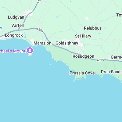
Surf spots nearby
- Marazion (1.8 mi)
- Praa Sands (2.4 mi)
- Danger Bay (3.9 mi)
- Newlyn Harbour Wall (4.7 mi)
- Porthleven (5.8 mi)
- Hawks Point (5.9 mi)
- Porthleven Pier (5.9 mi)
- Carbis Bay (6 mi)
- Sandy Acres (6.6 mi)
- Hayle Towans (6.9 mi)
Not Magic Seaweed (MSW)
Although we look a bit like Magic Seaweed we are not MagicSeaweed as they no longer exist...