Praa Sands Surf Report
| Wave height * | 3.5ft / 1.1m |
|---|---|
| Swell period | 11s |
| Swell direction | |
| Wind | |
| Sea temp | 11°C / 51°F |

10 day Praa Sands surf forecast
Sat
10/Jan
5.5ft
29
12
11
- Low 4:24am
- High 10:08am
- Low 5:00pm
- High 10:42pm
Sun
11/Jan
7.5ft
34
28
46
- Low 5:20am
- High 11:10am
- Low 5:59pm
- High 11:52pm
Mon
12/Jan
9ft
26
25
20
- Low 6:29am
- High 12:26pm
- Low 7:08pm
Tue
13/Jan
6ft
20
28
29
- High 1:08am
- Low 7:42am
- High 1:39pm
- Low 8:15pm
Wed
14/Jan
3.5ft
24
36
28
- High 2:12am
- Low 8:47am
- High 2:38pm
- Low 9:11pm
Thu
15/Jan
8ft
10
13
14
- High 3:03am
- Low 9:40am
- High 3:24pm
- Low 9:59pm
Fri
16/Jan
8.5ft
8
13
10
- High 3:45am
- Low 10:24am
- High 4:04pm
- Low 10:39pm
Sat
17/Jan
4.5ft
19
18
21
- High 4:22am
- Low 11:03am
- High 4:40pm
- Low 11:17pm
Sun
18/Jan
2.5ft
8
11
19
- High 4:58am
- Low 11:40am
- High 5:16pm
- Low 11:53pm
Mon
19/Jan
3ft
31
12
21
Sat 10th Jan
| 3:00 | 8ft | 14.7ft | 13s | 34mph (38mph) | |||
| 6:00 | 7ft | 13.4ft | 12s | 29mph (32mph) | |||
| 9:00 | 6.5ft | 11.7ft | 12s | 19mph (21mph) | |||
| 12:00 | 5.5ft | 10.1ft | 12s | 12mph (13mph) | |||
| 15:00 | 4.5ft | 8.8ft | 12s | 8mph (9mph) | |||
| 18:00 | 4ft | 7.7ft | 12s | 11mph (12mph) | |||
| 21:00 | 3.5ft | 6.9ft | 11s | 18mph (19mph) |
| Tide times |
|---|
| Low 4:24am (1.89m) |
| High 10:08am (4.54m) |
| Low 5:00pm (1.94m) |
| High 10:42pm (4.31m) |
| Daylight | |
|---|---|
| First light | 07:39 |
| Sunrise | 08:17 |
| Sunset | 16:41 |
| Dark | 17:19 |
Sun 11th Jan
| 3:00 | 4ft | 7ft | 11s | 28mph (33mph) | |||
| 6:00 | 7ft | 8.4ft | 7s | 34mph (44mph) | |||
| 9:00 | 7ft | 10ft | 8s | 30mph (39mph) | |||
| 12:00 | 7.5ft | 10.6ft | 9s | 28mph (41mph) | |||
| 15:00 | 10ft | 11.5ft | 8s | 36mph (51mph) | |||
| 18:00 | 10.5ft | 13.2ft | 9s | 46mph (59mph) | |||
| 21:00 | 10ft | 13ft | 10s | 32mph (43mph) |
| Tide times |
|---|
| Low 5:20am (2.10m) |
| High 11:10am (4.31m) |
| Low 5:59pm (2.10m) |
| High 11:52pm (4.21m) |
| Daylight | |
|---|---|
| First light | 07:39 |
| Sunrise | 08:16 |
| Sunset | 16:43 |
| Dark | 17:20 |
Mon 12th Jan
| 3:00 | 9.5ft | 13.5ft | 11s | 27mph (36mph) | |||
| 6:00 | 9.5ft | 13.3ft | 11s | 26mph (34mph) | |||
| 9:00 | 9ft | 13.1ft | 11s | 25mph (34mph) | |||
| 12:00 | 9ft | 12.9ft | 11s | 25mph (35mph) | |||
| 15:00 | 8.5ft | 12.5ft | 11s | 25mph (33mph) | |||
| 18:00 | 8.5ft | 12ft | 11s | 20mph (26mph) | |||
| 21:00 | 8ft | 11.3ft | 11s | 18mph (24mph) |
| Tide times |
|---|
| Low 6:29am (2.20m) |
| High 12:26pm (4.20m) |
| Low 7:08pm (2.14m) |
| Daylight | |
|---|---|
| First light | 07:38 |
| Sunrise | 08:15 |
| Sunset | 16:44 |
| Dark | 17:21 |
Tue 13th Jan
| 3:00 | 7ft | 10.4ft | 11s | 17mph (26mph) | |||
| 6:00 | 6.5ft | 9.8ft | 11s | 20mph (29mph) | |||
| 9:00 | 6ft | 9.5ft | 11s | 21mph (24mph) | |||
| 12:00 | 6ft | 9.1ft | 11s | 28mph (31mph) | |||
| 15:00 | 5ft | 8.5ft | 12s | 27mph (30mph) | |||
| 18:00 | 4.5ft | 8ft | 12s | 29mph (32mph) | |||
| 21:00 | 5ft | 7.6ft | 11s | 28mph (31mph) |
| Tide times |
|---|
| High 1:08am (4.26m) |
| Low 7:42am (2.17m) |
| High 1:39pm (4.26m) |
| Low 8:15pm (2.05m) |
| Daylight | |
|---|---|
| First light | 07:38 |
| Sunrise | 08:15 |
| Sunset | 16:46 |
| Dark | 17:23 |
Wed 14th Jan
| 3:00 | 4.5ft | 6.9ft | 11s | 22mph (26mph) | |||
| 6:00 | 5ft | 6.6ft | 10s | 24mph (30mph) | |||
| 9:00 | 4ft | 6.3ft | 11s | 31mph (37mph) | |||
| 12:00 | 3.5ft | 6.2ft | 13s | 36mph (46mph) | |||
| 18:00 | 4ft | 7.1ft | 13s | 29mph (37mph) | |||
| 21:00 | 7.5ft | 8.7ft | 7s | 28mph (35mph) |
| Tide times |
|---|
| High 2:12am (4.44m) |
| Low 8:47am (2.00m) |
| High 2:38pm (4.42m) |
| Low 9:11pm (1.87m) |
| Daylight | |
|---|---|
| First light | 07:37 |
| Sunrise | 08:14 |
| Sunset | 16:47 |
| Dark | 17:24 |
Thu 15th Jan
| 3:00 | 6ft | 8.7ft | 8s | 19mph (23mph) | |||
| 6:00 | 5ft | 8.8ft | 12s | 12mph (14mph) | |||
| 9:00 | 5.5ft | 9.8ft | 17s | 10mph (11mph) | |||
| 12:00 | 6.5ft | 12.5ft | 18s | 10mph (11mph) | |||
| 15:00 | 8ft | 14.6ft | 18s | 13mph (14mph) | |||
| 18:00 | 8ft | 14.9ft | 18s | 16mph (18mph) | |||
| 21:00 | 8ft | 14.5ft | 17s | 14mph (18mph) |
| Tide times |
|---|
| High 3:03am (4.67m) |
| Low 9:40am (1.78m) |
| High 3:24pm (4.61m) |
| Low 9:59pm (1.66m) |
| Daylight | |
|---|---|
| First light | 07:36 |
| Sunrise | 08:13 |
| Sunset | 16:49 |
| Dark | 17:25 |
Fri 16th Jan
| 3:00 | 7ft | 13.4ft | 16s | 12mph (14mph) | |||
| 6:00 | 7ft | 12.8ft | 16s | 9mph (10mph) | |||
| 9:00 | 7ft | 12.9ft | 16s | 8mph (10mph) | |||
| 12:00 | 7.5ft | 14.1ft | 16s | 7mph (9mph) | |||
| 15:00 | 8.5ft | 15.5ft | 16s | 13mph (14mph) | |||
| 18:00 | 8.5ft | 15.4ft | 16s | 10mph (11mph) | |||
| 21:00 | 8ft | 14.7ft | 16s | 10mph (11mph) |
| Tide times |
|---|
| High 3:45am (4.91m) |
| Low 10:24am (1.56m) |
| High 4:04pm (4.80m) |
| Low 10:39pm (1.47m) |
| Daylight | |
|---|---|
| First light | 07:36 |
| Sunrise | 08:12 |
| Sunset | 16:50 |
| Dark | 17:27 |
Sat 17th Jan
| 3:00 | 6.5ft | 12.5ft | 15s | 16mph (18mph) | |||
| 6:00 | 6ft | 11.4ft | 15s | 23mph (25mph) | |||
| 9:00 | 5.5ft | 10.4ft | 14s | 19mph (21mph) | |||
| 12:00 | 5ft | 9.2ft | 13s | 17mph (17mph) | |||
| 15:00 | 4.5ft | 8ft | 13s | 18mph (19mph) | |||
| 18:00 | 4ft | 7ft | 13s | 23mph (25mph) | |||
| 21:00 | 3.5ft | 6.5ft | 12s | 21mph (24mph) |
| Tide times |
|---|
| High 4:22am (5.11m) |
| Low 11:03am (1.35m) |
| High 4:40pm (4.97m) |
| Low 11:17pm (1.29m) |
| Daylight | |
|---|---|
| First light | 07:35 |
| Sunrise | 08:11 |
| Sunset | 16:52 |
| Dark | 17:28 |
Sun 18th Jan
| 3:00 | 3ft | 5.9ft | 11s | 12mph (15mph) | |||
| 6:00 | 3ft | 5.6ft | 11s | 9mph (12mph) | |||
| 9:00 | 2.5ft | 4.9ft | 11s | 8mph (9mph) | |||
| 12:00 | 2.5ft | 4.5ft | 10s | 5mph (5mph) | |||
| 15:00 | 2.5ft | 4.3ft | 10s | 11mph (12mph) | |||
| 18:00 | 2ft | 4ft | 10s | 15mph (16mph) | |||
| 21:00 | 2ft | 4.1ft | 10s | 19mph (20mph) |
| Tide times |
|---|
| High 4:58am (5.28m) |
| Low 11:40am (1.17m) |
| High 5:16pm (5.09m) |
| Low 11:53pm (1.16m) |
| Daylight | |
|---|---|
| First light | 07:34 |
| Sunrise | 08:10 |
| Sunset | 16:53 |
| Dark | 17:30 |
Mon 19th Jan
| 3:00 | 2ft | 4ft | 11s | 27mph (33mph) | |||
| 6:00 | 2ft | 4.5ft | 18s | 30mph (37mph) | |||
| 9:00 | 2.5ft | 5.3ft | 17s | 31mph (41mph) | |||
| 12:00 | 3ft | 5.7ft | 16s | 21mph (25mph) | |||
| 15:00 | 3ft | 5.9ft | 16s | 12mph (18mph) | |||
| 18:00 | 3ft | 5.9ft | 16s | 18mph (19mph) | |||
| 21:00 | 3ft | 5.8ft | 16s | 21mph (23mph) |
| Tide times |
|---|
| Daylight | |
|---|---|
| First light | 07:33 |
| Sunrise | 08:09 |
| Sunset | 16:55 |
| Dark | 17:31 |
Nearest buoys
Fast, powerful lefts and rights at the western end of the beach, often barrelling. When the banks are right the high tide shorey is the best
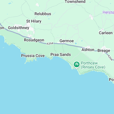
Surf spots nearby
- Perranuthnoe (2.4 mi)
- Porthleven (3.4 mi)
- Porthleven Pier (3.5 mi)
- Marazion (4.2 mi)
- Gunwalloe (5.8 mi)
- Danger Bay (6.3 mi)
- Newlyn Harbour Wall (7 mi)
- Church Cove (7 mi)
- Hawks Point (7.1 mi)
- Sandy Acres (7.3 mi)
Not Magic Seaweed (MSW)
Although we look a bit like Magic Seaweed we are not MagicSeaweed as they no longer exist...