Velzyland Surf Report
| Wave height * | 3.5ft / 1.1m |
|---|---|
| Swell period | 12s |
| Swell direction | |
| Wind | |
| Sea temp | 25°C / 78°F |

10 day Velzyland surf forecast
Mon
29/Dec
7ft
12
13
16
- Low 5:28am
- High 9:08am
- Low 3:42pm
- High 11:31pm
Tue
30/Dec
7ft
15
19
18
- Low 6:51am
- High 10:19am
- Low 4:26pm
Wed
31/Dec
6.5ft
17
17
19
- High 12:19am
- Low 7:51am
- High 11:28am
- Low 5:12pm
Thu
1/Jan
5ft
16
15
20
- High 1:04am
- Low 8:39am
- High 12:36pm
- Low 6:01pm
Fri
2/Jan
7ft
21
22
27
- High 1:49am
- Low 9:21am
- High 1:34pm
- Low 6:51pm
Sat
3/Jan
5.5ft
24
23
23
- High 2:33am
- Low 10:01am
- High 2:28pm
- Low 7:40pm
Sun
4/Jan
6ft
25
23
23
- High 3:15am
- Low 10:38am
- High 3:23pm
- Low 8:28pm
Mon
5/Jan
2ft
23
21
22
- High 3:55am
- Low 11:15am
- High 4:20pm
- Low 9:17pm
Tue
6/Jan
2ft
17
16
16
- High 4:33am
- Low 11:50am
- High 5:21pm
- Low 10:10pm
Mon 29th Dec
| 5:00 | 6ft | 7.1ft | 12s | 13mph (15mph) | |||
| 8:00 | 6.5ft | 7.5ft | 12s | 12mph (14mph) | |||
| 11:00 | 7ft | 8ft | 12s | 13mph (16mph) | |||
| 14:00 | 7ft | 8.3ft | 15s | 13mph (15mph) | |||
| 17:00 | 7.5ft | 8.4ft | 15s | 15mph (16mph) | |||
| 20:00 | 7ft | 8.4ft | 15s | 16mph (19mph) |
| Tide times |
|---|
| Low 5:28am (0.83m) |
| High 9:08am (1.02m) |
| Low 3:42pm (-0.05m) |
| High 11:31pm (2.24m) |
| Daylight | |
|---|---|
| First light | 06:45 |
| Sunrise | 07:09 |
| Sunset | 17:59 |
| Dark | 18:23 |
Tue 30th Dec
| 5:00 | 6.5ft | 8.2ft | 14s | 14mph (15mph) | |||
| 8:00 | 6.5ft | 8.1ft | 14s | 15mph (17mph) | |||
| 11:00 | 6.5ft | 8.1ft | 14s | 16mph (19mph) | |||
| 14:00 | 7ft | 8.5ft | 14s | 19mph (20mph) | |||
| 17:00 | 7ft | 8.7ft | 14s | 17mph (20mph) | |||
| 20:00 | 7ft | 8.9ft | 16s | 18mph (20mph) |
| Tide times |
|---|
| Low 6:51am (0.64m) |
| High 10:19am (0.82m) |
| Low 4:26pm (-0.12m) |
| Daylight | |
|---|---|
| First light | 06:45 |
| Sunrise | 07:09 |
| Sunset | 17:59 |
| Dark | 18:24 |
Wed 31st Dec
| 5:00 | 6.5ft | 8.6ft | 14s | 18mph (19mph) | |||
| 8:00 | 6.5ft | 8.4ft | 14s | 17mph (19mph) | |||
| 11:00 | 6.5ft | 8.1ft | 14s | 17mph (19mph) | |||
| 14:00 | 6.5ft | 7.8ft | 13s | 17mph (19mph) | |||
| 17:00 | 6ft | 7.7ft | 13s | 17mph (19mph) | |||
| 20:00 | 5.5ft | 7.5ft | 14s | 19mph (21mph) |
| Tide times |
|---|
| High 12:19am (2.51m) |
| Low 7:51am (0.46m) |
| High 11:28am (0.70m) |
| Low 5:12pm (-0.16m) |
| Daylight | |
|---|---|
| First light | 06:46 |
| Sunrise | 07:10 |
| Sunset | 18:00 |
| Dark | 18:24 |
Thu 1st Jan
| 5:00 | 5.5ft | 7.1ft | 13s | 17mph (20mph) | |||
| 8:00 | 5ft | 6.8ft | 12s | 16mph (19mph) | |||
| 11:00 | 5ft | 6.6ft | 12s | 15mph (17mph) | |||
| 14:00 | 5ft | 6.4ft | 12s | 15mph (16mph) | |||
| 17:00 | 5ft | 6.3ft | 12s | 16mph (18mph) | |||
| 20:00 | 4.5ft | 6.6ft | 12s | 20mph (22mph) |
| Tide times |
|---|
| High 1:04am (2.70m) |
| Low 8:39am (0.31m) |
| High 12:36pm (0.66m) |
| Low 6:01pm (-0.19m) |
| Daylight | |
|---|---|
| First light | 06:46 |
| Sunrise | 07:10 |
| Sunset | 18:01 |
| Dark | 18:25 |
Fri 2nd Jan
| 5:00 | 5.5ft | 7.4ft | 13s | 18mph (21mph) | |||
| 8:00 | 7ft | 7.6ft | 14s | 21mph (24mph) | |||
| 11:00 | 7.5ft | 7.9ft | 13s | 23mph (25mph) | |||
| 14:00 | 7ft | 8.3ft | 13s | 22mph (24mph) | |||
| 17:00 | 8.5ft | 9.1ft | 10s | 25mph (28mph) | |||
| 20:00 | 9ft | 9.9ft | 9s | 27mph (31mph) |
| Tide times |
|---|
| High 1:49am (2.80m) |
| Low 9:21am (0.23m) |
| High 1:34pm (0.67m) |
| Low 6:51pm (-0.18m) |
| Daylight | |
|---|---|
| First light | 06:46 |
| Sunrise | 07:10 |
| Sunset | 18:01 |
| Dark | 18:25 |
Sat 3rd Jan
| 5:00 | 7.5ft | 8.6ft | 12s | 23mph (24mph) | |||
| 8:00 | 6ft | 8.3ft | 13s | 24mph (27mph) | |||
| 11:00 | 6ft | 8.2ft | 12s | 23mph (26mph) | |||
| 14:00 | 5.5ft | 8ft | 12s | 23mph (23mph) | |||
| 17:00 | 5.5ft | 8ft | 12s | 22mph (24mph) | |||
| 20:00 | 6.5ft | 8.2ft | 11s | 23mph (26mph) |
| Tide times |
|---|
| High 2:33am (2.81m) |
| Low 10:01am (0.18m) |
| High 2:28pm (0.72m) |
| Low 7:40pm (-0.11m) |
| Daylight | |
|---|---|
| First light | 06:47 |
| Sunrise | 07:11 |
| Sunset | 18:02 |
| Dark | 18:26 |
Sun 4th Jan
| 5:00 | 6.5ft | 8ft | 8s | 24mph (28mph) | |||
| 8:00 | 6ft | 8.1ft | 8s | 25mph (28mph) | |||
| 11:00 | 6.5ft | 8.5ft | 8s | 22mph (24mph) | |||
| 14:00 | 6ft | 8.2ft | 8s | 23mph (25mph) | |||
| 17:00 | 5.5ft | 8ft | 8s | 23mph (27mph) | |||
| 20:00 | 2.5ft | 8.4ft | 8s | 23mph (27mph) |
| Tide times |
|---|
| High 3:15am (2.72m) |
| Low 10:38am (0.16m) |
| High 3:23pm (0.78m) |
| Low 8:28pm (0.02m) |
| Daylight | |
|---|---|
| First light | 06:47 |
| Sunrise | 07:11 |
| Sunset | 18:03 |
| Dark | 18:27 |
Mon 5th Jan
| 5:00 | 2.5ft | 7.8ft | 8s | 25mph (26mph) | |||
| 8:00 | 2.5ft | 8.1ft | 8s | 23mph (29mph) | |||
| 11:00 | 2.5ft | 8ft | 8s | 24mph (27mph) | |||
| 14:00 | 2ft | 7.4ft | 8s | 21mph (24mph) | |||
| 17:00 | 2ft | 7.3ft | 8s | 23mph (25mph) | |||
| 20:00 | 2ft | 6.9ft | 8s | 22mph (24mph) |
| Tide times |
|---|
| High 3:55am (2.56m) |
| Low 11:15am (0.15m) |
| High 4:20pm (0.87m) |
| Low 9:17pm (0.21m) |
| Daylight | |
|---|---|
| First light | 06:47 |
| Sunrise | 07:11 |
| Sunset | 18:03 |
| Dark | 18:27 |
Tue 6th Jan
| 5:00 | 3ft | 5.8ft | 8s | 18mph (19mph) | |||
| 8:00 | 2ft | 5.9ft | 8s | 17mph (19mph) | |||
| 11:00 | 2ft | 6ft | 8s | 17mph (18mph) | |||
| 14:00 | 2ft | 5.7ft | 8s | 16mph (16mph) | |||
| 17:00 | 1.5ft | 5.2ft | 8s | 13mph (14mph) | |||
| 20:00 | 2.5ft | 4.9ft | 8s | 16mph (16mph) |
| Tide times |
|---|
| High 4:33am (2.33m) |
| Low 11:50am (0.15m) |
| High 5:21pm (0.98m) |
| Low 10:10pm (0.43m) |
| Daylight | |
|---|---|
| First light | 06:47 |
| Sunrise | 07:11 |
| Sunset | 18:04 |
| Dark | 18:28 |
Wed 7th Jan
| 5:00 | 2ft | 4.6ft | 8s | 12mph (14mph) | |||
| 8:00 | 1.5ft | 4.3ft | 8s | 11mph (12mph) | |||
| 11:00 | 1.5ft | 4.2ft | 8s | 9mph (10mph) | |||
| 14:00 | 3.5ft | 4.2ft | 13s | 11mph (10mph) |
| Tide times |
|---|
| High 5:09am (2.06m) |
| Low 12:24pm (0.17m) |
| High 6:29pm (1.10m) |
| Daylight | |
|---|---|
| First light | 06:48 |
| Sunrise | 07:12 |
| Sunset | 18:05 |
| Dark | 18:29 |
Nearest buoys
High performance right breaking over shallow reef. Often hollow, often crowded. Mind your manners and the locals might ignore you!
Named after legendary 1960s shaper Dale Velzy
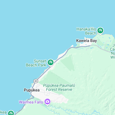
Surf spots nearby
- Sunset Beach (0.8 mi)
- Rocky Point (1.4 mi)
- Pipeline (1.7 mi)
- Backdoor (1.9 mi)
- Rockpile (2.2 mi)
- Outside Log Cabins (2.4 mi)
- Turtle Bay (2.5 mi)
- Off The Wall (2.6 mi)
- Log Cabins (3 mi)
- Rubber Duckies (3.3 mi)
Not Magic Seaweed (MSW)
Although we look a bit like Magic Seaweed we are not MagicSeaweed as they no longer exist...